Street view
 |
|

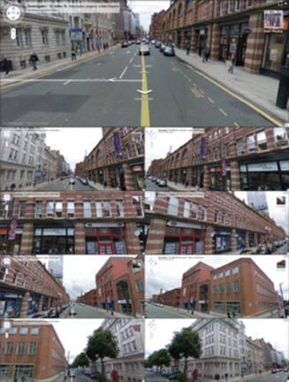
A road junction in Manchester, England, showing nine different angles
|
|
| Initial release | May 25, 2007 |
|---|---|
| Stable release |
Release 212 (see list) / February 28, 2017
|
| Available in | Multiple languages |
| Website | Google Street View |
Google Street View is a technology featured in Google Maps and Google Earth that provides panoramic views from positions along many streets in the world. It was launched in 2007 in several cities in the United States, and has since expanded to include cities and rural areas worldwide. Streets with Street View imagery available are shown as blue lines on Google Maps.
Google Street View displays panoramas of stitched images. Most photography is done by car, but some is done by trekker, tricycle, walking, boat, snowmobile, and underwater apparatus.
Street View had its inception in 2001 with The Stanford CityBlock Project, a Google-sponsored Stanford University research project. The project ended in June 2006, and its technology was folded into StreetView.
Street View is available as a component of Google Maps, as a web application, and as a mobile application for Android and iOS. Originally, Google Maps used Adobe Flash for Street View. Google overhauled Google Maps in 2013. The newer version uses JavaScript extensively and provides a JavaScript application programming interface. At the time of their release, the new Google Maps and Street View are measured slower than the old version in various setups. A user can switch to the old version of Google Maps, which is especially useful when Google Maps is more sluggish than usual.
As noted above, the drag-and-drop Pegman icon is the primary user interface element used by Google to connect Maps to Street View. His name comes from his resemblance to a clothespeg. When not in use, Pegman sits atop the Google Maps zoom controls. Occasionally Pegman "dresses up" for special events or is joined by peg friends in Google Maps. When dragged into Street View near Area 51, he becomes a flying saucer. When viewing older views, the Pegman in the minimap changes to Doc Brown from Back to the Future.
...
Wikipedia
