Strausstown, Pennsylvania
| Strausstown, Pennsylvania | |
| Unincorporated community | |
|
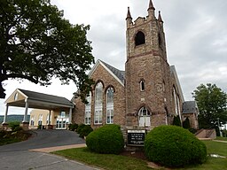
Zion Blue Mountain Church in Strausstown.
|
|
| Country | United States |
|---|---|
| State | Pennsylvania |
| County | Berks |
| Township | Upper Tulpehocken |
| Elevation | 574 ft (175.0 m) |
| Coordinates | 40°29′31″N 76°11′03″W / 40.49194°N 76.18417°WCoordinates: 40°29′31″N 76°11′03″W / 40.49194°N 76.18417°W |
| Area | 0.2 sq mi (0.5 km2) |
| - land | 0.2 sq mi (1 km2) |
| - water | 0.0 sq mi (0 km2) |
| Population | 342 (2010) |
| Density | 1,919.6/sq mi (741.2/km2) |
| Timezone | EST (UTC-5) |
| - summer (DST) | EDT (UTC-4) |
| ZIP code | 19559 |
| Area code | 610 and 484 (610-Exchange: 488) |
Strausstown is a village and former borough located in Upper Tulpehocken Township in Berks County, Pennsylvania, United States. The population was 342 at the 2010 census.
Strausstown is located at 40°29′31″N 76°11′3″W / 40.49194°N 76.18417°W (40.492053, -76.184102).
According to the United States Census Bureau, the village has a total area of 0.2 square miles (0.5 km²), all of it land.
Strausstown was founded in 1840 by John Strauss. It is located at the source of several tributaries to Northkill Creek.
In 2016, the borough of Strausstown voted to merge with surrounding Upper Tulpehocken Township.
As of the census of 2000, there were 339 people, 139 households, and 89 families residing in the borough. The population density was 1,919.6 people per square mile (727.2/km²). There were 146 housing units at an average density of 826.7 per square mile (313.2/km²). The racial makeup of the borough was 98.23% White, 1.47% Asian, and 0.29% from two or more races. Hispanic or Latino of any race were 0.59% of the population.
...
Wikipedia


