Straight River (central Minnesota)
| Straight River | |
| River | |
|
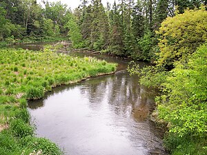
The Straight River in Straight River Township in 2007
|
|
| Country | United States |
|---|---|
| State | Minnesota |
| Source | |
| - location | Pine Point Township, Becker County |
| - elevation | 1,506 ft (459 m) |
| - coordinates | 47°00′08″N 95°18′34″W / 47.00222°N 95.30944°W |
| Mouth | Fish Hook River |
| - location | Hubbard Township, Hubbard County |
| - elevation | 1,384 ft (422 m) |
| - coordinates | 46°52′08″N 95°01′55″W / 46.86889°N 95.03194°WCoordinates: 46°52′08″N 95°01′55″W / 46.86889°N 95.03194°W |
| Length | 22.7 mi (37 km) |
| Basin | 60 sq mi (155 km2) approx. |
| Discharge | for near Park Rapids |
| - average | 60.8 cu ft/s (2 m3/s) |
| - max | 149 cu ft/s (4 m3/s) |
| - min | 21 cu ft/s (1 m3/s) |
The Straight River is a tributary of the Fish Hook River, 23 miles (37 km) long, in north-central Minnesota in the United States. Via the Fish Hook, Shell, and Crow Wing Rivers, it is part of the watershed of the Mississippi River, draining an area of approximately 60 square miles (160 km2) in a rural region. The river is known as one of Minnesota's best trout fishing streams.
The river's name is a translation of the Ojibwe name for Straight Lake, through which the river flows near its source.
The Straight River rises in the White Earth Indian Reservation and Two Inlets State Forest, approximately 6 miles (9.7 km) northeast of Pine Point in Pine Point Township in northeastern Becker County. It flows initially southeastwardly, passing through Straight Lake, then east-southeastwardly into southwestern Hubbard County. It flows into the Fish Hook River in Hubbard Township, approximately 4 miles (6.4 km) south of Park Rapids. The river flows in the Northern Lakes and Forests ecoregion, which is characterized by conifer and hardwood forests on flat and rolling till plains and outwash plains.
...
Wikipedia


