Strafford, New Hampshire
| Strafford, New Hampshire | |
|---|---|
| Town | |
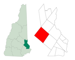
 Location within Strafford County, New Hampshire |
|
| Coordinates: 43°16′13″N 71°07′34″W / 43.27028°N 71.12611°WCoordinates: 43°16′13″N 71°07′34″W / 43.27028°N 71.12611°W | |
| Country | United States |
| State | New Hampshire |
| County | Strafford |
| Incorporated | 1820 |
| Government | |
| • Board of selectmen | Lynn Sweet, Chair Scott Young Bryant Scott |
| Area | |
| • Total | 51.4 sq mi (33.2 km2) |
| • Land | 49.2 sq mi (127.3 km2) |
| • Water | 2.2 sq mi (5.8 km2) |
| Elevation | 595 ft (181 m) |
| Population (2010) | |
| • Total | 3,991 |
| • Density | 78/sq mi (120/km2) |
| Time zone | EST (UTC-5) |
| • Summer (DST) | EDT (UTC-4) |
| ZIP code | 03884 |
| Area code(s) | 603 |
| FIPS code | 33-73860 |
| GNIS feature ID | 0873726 |
| Website | strafford |
Strafford is a town in Strafford County, New Hampshire, United States. The population was 3,991 at the 2010 census. The two main settlements in town are the villages of Center Strafford and Bow Lake Village.
Once part of Barrington, Strafford was set off due to the lengthy travel required to attend town meetings. Settled prior to the Revolution, the town incorporated in 1820, taking its name from the county in which it is located. Strafford County had been organized in 1773 during the administration of Colonial Governor John Wentworth, and named in honor of Thomas Wentworth, Earl of Strafford.
The Austin Academy once stood in the center of Strafford village. George Cate, a wealthy shoe manufacturer, visited the school at the request of its principal Alvin E. Thomas and was so impressed with the school that he left at his death $200,000 on the condition that his name be added to that of Mr. Austin. After his death, the hundred-acre farm of George Washington Foss was purchased and soon a beautiful new building, designed by well-known Boston architect, Richardson, sat on the hill with the name on its facade, "Austin-Cate Academy - 1903". After the property was purchased by the state for a National Guard training center, all of the original wooden buildings were torn down and replaced by new brick buildings.
According to the United States Census Bureau, the town has a total area of 51.4 square miles (133 km2), of which 49.2 sq mi (127 km2) is land and 2.2 sq mi (5.7 km2) is water, comprising 4.38% of the town. Bow Lake, popular with fishermen, covers 1,160 acres (470 ha). Strafford is drained by the Isinglass, Big, and Berrys rivers.
...
Wikipedia
