Strachur
Strachur
|
|
|---|---|
 Sunset on Loch Fyne near Strachur. |
|
| Strachur shown within Argyll and Bute | |
| OS grid reference | NN 09600 01400 |
| Council area |
|
| Lieutenancy area |
|
| Country | Scotland |
| Sovereign state | United Kingdom |
| Post town | DUNOON, ARGYLL |
| Postcode district | PA27 |
| Dialling code | 01369 |
| EU Parliament | Scotland |
| UK Parliament |
|
| Scottish Parliament |
|
Strachur; (Scottish Gaelic: Srath Chura) and Strathlachlan; (Scottish Gaelic: Srath Lachlainn) are united parishes located on the Cowal peninsula, in Argyll and Bute, Scotland.
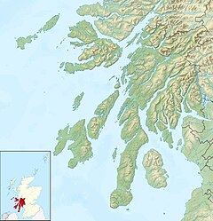
Cowal is the large peninsula situated between Loch Long to the east and Loch Fyne to the west and bordered to the north by the arterial road A83. Strachur is located 7 miles south of the A83, linking Loch Lomond and A82 to Inveraray, Lochgilphead and Campbeltown, and is 23 miles north of Dunoon, the main town of the Cowal peninsula.
The area around Strachur borders the Loch Lomond and the Trossachs National Park. The parish is bounded along its north-west side by Loch Fyne - Strachur forming its north-western district, and Strathlachlan its south-western one; and it is bounded on other sides by the parishes of Lochgoilhead, Kilmun, Dunoon, and Kilmodan. It is mostly uplands, and altitudes rise to 3000 feet.
Loch Eck touches the parish for three miles on the south-east.
Local transport is by bus with a regular service between Dunoon and Inveraray, and Dunoon and Carrick Castle, situated south of Lochgoilhead on Loch Goil. Access to Inveraray used to be via the ferry from St Catherine's just north of Strachur. This ferry closed in the 1960s.
The name 'Strachur' comes from the Gaelic for 'Valley (srath) of the Cur' - Cur being the name of the river flowing from the hills east of Strachur village, turning south to flow into Loch Eck.
...
Wikipedia

