Cowal
Cowal
|
|
|---|---|
|
Cowal shown within Argyll |
|
| Cowal shown within Argyll and Bute | |
| Population | 15,560 (2013 Est) |
| OS grid reference | NS 09111 85254 |
| Council area | |
| Lieutenancy area |
|
| Country | Scotland |
| Sovereign state | United Kingdom |
| EU Parliament | Scotland |
| UK Parliament | |
| Scottish Parliament | |
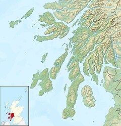
Cowal; (Scottish Gaelic: Còmhghall) is a peninsula in Argyll and Bute in the west of Scotland that extends into the Firth of Clyde.
The northern part of the peninsula is covered by the Argyll Forest Park managed by Forestry Commission Scotland. The Arrochar Alps and Ardgoil peninsula in the north fringe the edges of the sea lochs whilst the forest park spreads out across the hillsides and mountain passes, making Cowal one of the remotest areas in the west of Scotland. The Loch Lomond and The Trossachs National Park extends into Cowal. The peninsula is separated from Kintyre by Loch Fyne, and from Inverclyde and North Ayrshire to the east by the Firth of Clyde.Loch Long and its arm, Loch Goil are to the north-east. The south of the peninsula is split into three forks by Loch Striven and Loch Riddon (Loch Ruel). The Isle of Bute lies to the south separated by the narrow Kyles of Bute which connect the Firth of Clyde to Loch Riddon.
Cowal's only burgh is Dunoon in the south-east, from which ferries sail to Gourock in Inverclyde. Other ferries run from Portavadie in the west to Tarbert in Kintyre, and from Colintraive in the south to Rhubodach on the Isle of Bute.
...
Wikipedia

