Firth of Clyde
| Firth of Clyde | |
|---|---|

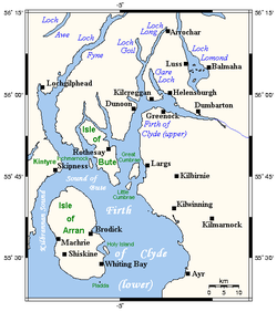
Map of the Firth of Clyde.
|
|
| Location | Scotland, United Kingdom |
| Coordinates |
Coordinates: 55°40′N 5°00′W / 55.667°N 5.000°W grid reference NS1525265213 |
| Basin countries | Scotland, United Kingdom |
| Surface elevation | Sea level |
| Frozen | no |
| Islands | Isle of Arran, Isle of Bute, Isle of Cumbrae |
The Firth of Clyde encloses the largest and deepest coastal waters in the British Isles, sheltered from the Atlantic Ocean by the Kintyre peninsula which encloses the outer firth in Argyll and Ayrshire, Scotland. The Kilbrannan Sound is a large arm of the Firth of Clyde, separating the Kintyre Peninsula from the Isle of Arran. Within the Firth of Clyde is another major island - the Isle of Bute. Given its strategic location, at the entrance to the middle/upper Clyde, Bute played a vitally important military (naval) role during World War II.
The Firth's climate enjoys the benefit of the Gulf Stream from America.
At its entrance the firth is some 26 miles (42 km) wide. Its upper reaches include an area where it is joined by Loch Long and the Gare Loch. This includes the large anchorage off Greenock known as the Tail of the Bank in reference to the sandbar which separates the firth from the estuary of the River Clyde. The Clyde is still almost 2 miles (3.2 km) wide at the sandbar, and its upper tidal limit is at the tidal Weir adjacent to Glasgow Green.
The cultural and geographical distinction between the firth and the River Clyde is vague, and people will sometimes refer to Dumbarton as being on the Firth of Clyde, while the population of Port Glasgow and Greenock frequently refer to the firth to their north as "the river". In Scottish Gaelic the landward end is called Linne Chluaidh (pronounced [ʎiɲəˈxlˠ̪uəj]) (meaning the same as the English), while the area around the south of Arran, Kintyre and Ayrshire/Galloway is An Linne Ghlas [ə ʎiɲə ɣlˠ̪as̪].
...
Wikipedia

