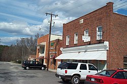
Stony Creek, VA
| Stony Creek, Virginia | |
|---|---|
| Town | |

Downtown
|
|
 Location of Stony Creek, Virginia |
|
| Coordinates: 36°56′47″N 77°23′59″W / 36.94639°N 77.39972°WCoordinates: 36°56′47″N 77°23′59″W / 36.94639°N 77.39972°W | |
| Country | United States |
| State | Virginia |
| County | Sussex |
| Area | |
| • Total | 0.6 sq mi (1.5 km2) |
| • Land | 0.6 sq mi (1.5 km2) |
| • Water | 0.0 sq mi (0.0 km2) |
| Elevation | 95 ft (29 m) |
| Population (2010) | |
| • Total | 198 |
| Time zone | Eastern (EST) (UTC-5) |
| • Summer (DST) | EDT (UTC-4) |
| ZIP code | 23882 |
| Area code(s) | 434 |
| FIPS code | 51-75840 |
| GNIS feature ID | 1500170 |
Stony Creek is a town in Sussex County, Virginia, United States. The population was 198 at the 2010 census.
Glenview, Nottoway Archeological Site, and Rose Bower are listed on the National Register of Historic Places.
Stony Creek is located at 36°56′47″N 77°23′59″W / 36.94639°N 77.39972°W (36.946277, -77.399837).
According to the United States Census Bureau, the town has a total area of 0.6 square miles (1.5 km²), all of it land.
As of the census of 2000, there were 202 people, 99 households, and 56 families residing in the town. The population density was 350.6 people per square mile (134.5/km²). There were 118 housing units at an average density of 204.8 per square mile (78.6/km²). The racial makeup of the town was 69.80% White, 29.21% African American and 0.99% Asian.
There were 99 households out of which 16.2% had children under the age of 18 living with them, 45.5% were married couples living together, 7.1% had a female householder with no husband present, and 43.4% were non-families. 38.4% of all households were made up of individuals and 16.2% had someone living alone who was 65 years of age or older. The average household size was 2.04 and the average family size was 2.71.
...
Wikipedia
