Stolberg (Harz)
| Stolberg | ||
|---|---|---|
| Ortsteil of Südharz | ||
 |
||
|
||
| Coordinates: 51°34′N 10°57′E / 51.567°N 10.950°ECoordinates: 51°34′N 10°57′E / 51.567°N 10.950°E | ||
| Country | Germany | |
| State | Saxony-Anhalt | |
| District | Mansfeld-Südharz | |
| Municipality | Südharz | |
| Area | ||
| • Total | 67.52 km2 (26.07 sq mi) | |
| Elevation | 340 m (1,120 ft) | |
| Population (2009-12-31) | ||
| • Total | 1,286 | |
| • Density | 19/km2 (49/sq mi) | |
| Time zone | CET/CEST (UTC+1/+2) | |
| Postal codes | 06547 | |
| Dialling codes | 034654 | |
| Vehicle registration | SGH | |
| Website | www.stadt-stolberg.de | |
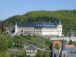
![]() Stolberg is a town (sometimes itself called 'Harz' in historical references) and a former municipality in the district of Mansfeld-Südharz, in the German State of Saxony-Anhalt, Germany. It is situated in the southern part of the Harz mountains, about 27 kilometres (17 mi) west of Sangerhausen, and 13 km (8.1 mi) northeast of Nordhausen. Since 1 September 2010, it has been part of the municipality of Südharz.
Stolberg is a town (sometimes itself called 'Harz' in historical references) and a former municipality in the district of Mansfeld-Südharz, in the German State of Saxony-Anhalt, Germany. It is situated in the southern part of the Harz mountains, about 27 kilometres (17 mi) west of Sangerhausen, and 13 km (8.1 mi) northeast of Nordhausen. Since 1 September 2010, it has been part of the municipality of Südharz.
Stolberg was established as a settlement for miners in around AD 1000, although there is evidence of mining in the area as far back as 794. The name of the name is derived from the German words Stollen = "[mining] gallery" and Berg = "hill". Iron, copper, silver, tin and gold were extracted there. Town status was awarded to Stolberg (Harz) before 1300.
During the German Peasants' War, Stolberg was the site of several battles, the peasants being led by Thomas Müntzer who was born in the town. On 2 May 1525, rebellious peasants invaded the town and forced the ruling Count Botho of Stolberg to accept their demands, the 24 Stolberg Articles. These were quickly revoked, however, following the defeat of the peasants.
...
Wikipedia


