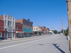
Stevenson, Alabama
| Stevenson | |
|---|---|
| City | |

Historic District
|
|
 Location in Jackson County and the state of Alabama |
|
| Coordinates: 34°52′10″N 85°49′55″W / 34.86944°N 85.83194°W | |
| Country | United States |
| State | Alabama |
| County | Jackson |
| Area | |
| • Total | 5.2 sq mi (13.6 km2) |
| • Land | 4.9 sq mi (12.8 km2) |
| • Water | 0.3 sq mi (0.8 km2) |
| Elevation | 653 ft (199 m) |
| Population (2000) | |
| • Total | 1,770 |
| • Density | 340.4/sq mi (130.1/km2) |
| Time zone | Central (CST) (UTC-6) |
| • Summer (DST) | CDT (UTC-5) |
| ZIP code | 35772 |
| Area code(s) | 256 |
| FIPS code | 01-73080 |
| GNIS feature ID | 0127370 |
Stevenson is a city in Jackson County, Alabama, United States, and is included in the Chattanooga-Cleveland-Dalton, TN-GA-AL Combined Statistical Area. Sources listed either 1866 or 1867 as the year incorporation, but that seems to conflict with the dates given for the town being granted a charter. It did not first appear on the U.S. Census until 1880, where it was the second largest town in Jackson County behind Scottsboro. Since 1900, it has been the third largest town behind either Scottsboro and Bridgeport or vice versa. At the 2010 census, the population of the city was 2,046, up from 1,770 in 2000.
Stevenson is located at 34°52′10″N 85°49′55″W / 34.86944°N 85.83194°W (34.869442, -85.831829).
According to the U.S. Census Bureau, the city has a total area of 5.2 square miles (13 km2), of which 4.9 square miles (13 km2) is land and 0.3 square miles (0.78 km2) (5.71%) is water.
In the 2000 census, there were 1,770 people, 795 households, and 508 families residing in the city. The population density was 357.8 per square mile (138.1/km²). There were 948 housing units at an average density of 191.6 per square mile (73.9/km²). The racial makeup of the city was 72.88% White, 22.37% Black or African American, 0.90% Native American, 0.11% Asian, 1.30% from other races, and 2.43% from two or more races. 1.53% of the population were Hispanic or Latino of any race.
...
Wikipedia
