Sterling, Connecticut
| Sterling, Connecticut | ||
|---|---|---|
| Town | ||

Post Office
|
||
|
||
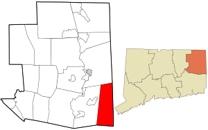
 Location in Windham County and the state of Connecticut. |
||
| Coordinates: 41°42′08″N 71°48′59″W / 41.70222°N 71.81639°WCoordinates: 41°42′08″N 71°48′59″W / 41.70222°N 71.81639°W | ||
| Country | United States | |
| State | Connecticut | |
| NECTA | Danielson | |
| Region | Southeastern Connecticut | |
| Incorporated | 1794 | |
| Government | ||
| • Type | Selectman-town meeting | |
| • First selectman | Russell M. Gray (R) | |
| • Selectman | Lincoln A. Cooper (R) | |
| • Selectman | John F. Firlik (D) | |
| Area | ||
| • Total | 27.3 sq mi (70.7 km2) | |
| • Land | 27.2 sq mi (70.5 km2) | |
| • Water | 0.1 sq mi (0.2 km2) | |
| Elevation | 384 ft (117 m) | |
| Population (2005) | ||
| • Total | 3,519 | |
| • Density | 129/sq mi (50/km2) | |
| Time zone | Eastern (UTC-5) | |
| • Summer (DST) | Eastern (UTC-4) | |
| ZIP code | 06377, 06373 | |
| Area code(s) | 860 | |
| FIPS code | 09-73420 | |
| GNIS feature ID | 0213512 | |
| Website | http://www.sterlingct.us/ | |
Sterling is a town in Windham County, Connecticut, United States. The population was 3,099 at the 2000 census.
The town was incorporated in 1794 following approval of the CT Assembly, and was carved from northern part of the Town of Voluntown. Le Comte de Rochambeau, Jean Baptiste Donatien de Vimeur, marched through and camped in the town during the American Revolutionary War on his way from landing at Narragansett Bay to join George Washington's forces on the Hudson River in 1781. A cotton mill was first established in Sterling in 1800. Charles Dow, of Dow Jones fame, was born in this community.
According to the United States Census Bureau, the town has a total area of 27.3 square miles (71 km2), of which, 27.2 square miles (70 km2) of it is land and 0.1 square miles (0.26 km2) of it (0.29%) is water.
As of the census of 2000, there were 3,099 people, 1,116 households, and 835 families residing in the town. Sterling's population increased 23.6% between 2000 and 2010, making it the third fastest-growing municipality in Connecticut that decade. The population density was 113.8 people per square mile (43.9/km²). There were 1,193 housing units at an average density of 43.8 per square mile (16.9/km²). The racial makeup of the town was 99.19% White, 0.71% Native American, 0.32% Asian, 0.03% Pacific Islander, 0.16% from other races, and 2.42% from two or more races. Hispanic or Latino of any race were 1.32% of the population.
...
Wikipedia

