Stein, Aargau
| Stein | ||
|---|---|---|

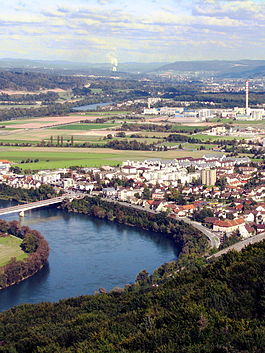
Stein and the Rhine River
|
||
|
||
| Coordinates: 47°33′N 7°57′E / 47.550°N 7.950°ECoordinates: 47°33′N 7°57′E / 47.550°N 7.950°E | ||
| Country | Switzerland | |
| Canton | Aargau | |
| District | Rheinfelden | |
| Area | ||
| • Total | 2.81 km2 (1.08 sq mi) | |
| Elevation | 299 m (981 ft) | |
| Population (Dec 2015) | ||
| • Total | 3,136 | |
| • Density | 1,100/km2 (2,900/sq mi) | |
| Postal code | 4332 | |
| SFOS number | 4260 | |
| Surrounded by | Bad Säckingen (DE-BW), Mumpf, Münchwilen, Obermumpf, Sisseln | |
| Website |
www SFSO statistics |
|
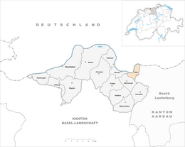
Stein is a municipality in the district of Rheinfelden in the canton of Aargau, Switzerland.
The town lies across the Rhine River from Bad Säckingen in the German state of Baden-Württemberg. Two bridges link the two city, one vehicular (Fridolinsbrücke) and the other, the Holzbrücke pedestrian bridge.
The Stein-Säckingen train station is located in Stein.
Stein has an area, as of 2009[update], of 2.81 square kilometers (1.08 sq mi). Of this area, 0.8 km2 (0.31 sq mi) or 28.5% is used for agricultural purposes, while 0.62 km2 (0.24 sq mi) or 22.1% is forested. Of the rest of the land, 1.1 km2 (0.42 sq mi) or 39.1% is settled (buildings or roads), 0.29 km2 (0.11 sq mi) or 10.3% is either rivers or lakes.
Of the built up area, industrial buildings comprise approximately 8.9% of the total area; housing and buildings account for 13.9% transportation infrastructure, 13.5%, parks, with green belts and sports fields making up 2.1%. Out of the forested land, 19.9% of the total land area is heavily forested and 2.1% is covered with orchards or small clusters of trees. Of the agricultural land, 19.9% is used for growing crops and 7.1% is pastures, while 1.4% is used for orchards or vine crops. All the water in the municipality is in rivers and streams.
The blazon of the municipal coat of arms is Gules a Fiddle Argent bendwise with neck downwards.
...
Wikipedia


