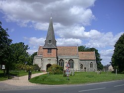
Steeple Morden
| Steeple Morden | |
|---|---|
 SS Peter and Paul |
|
| Steeple Morden shown within Cambridgeshire | |
| Population | 963 (2001) 1,078 (2011) |
| OS grid reference | TL286425 |
| District | |
| Shire county | |
| Region | |
| Country | England |
| Sovereign state | United Kingdom |
| Post town | ROYSTON |
| Postcode district | SG8 |
| Dialling code | 01763 |
| EU Parliament | East of England |
Steeple Morden is a village and civil parish in Cambridgeshire, England, about 15 miles (24 km) south west of Cambridge and 5 miles (8 km) west of Royston. It is part of the South Cambridgeshire local government district.
The parish is combined with the parishes of Abington Pigotts, Guilden Morden and Tadlow to form "The Mordens" ward, which is represented on South Cambridgeshire District Council by one councillor.
Steeple Morden parish covers and area of 1,549 hectares (3,830 acres) in a long thin shape stretching from the River Cam at its northern border with Tadlow and Croydon-cum-Clapton to the ancient Icknield Way (now the A505 road) at its southern border with Hertfordshire. Its long western border with Guilden Morden and eastern border with Abington Pigotts and Litlington largely follow streams.
An airfield opened at RAF Steeple Morden in 1938, covering 175 acres to the east of Cheyney Water. It began as a satellite of the base at RAF Bassingbourn and was later used by the 355th Fighter Group of the United States Air Force. The site of the airfield has now been returned to agricultural use. although the concrete taxiways and runways still remain, part of which is laid on a stretch of local byway known as 'The stret'
...
Wikipedia

