Royston, Hertfordshire
| Royston | |
|---|---|
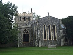
 St John the Baptist, Royston |
|
| Royston shown within Hertfordshire | |
| Population | 15,781 (2011 Census) |
| OS grid reference | TL357406 |
| Civil parish |
|
| District | |
| Shire county | |
| Region | |
| Country | England |
| Sovereign state | United Kingdom |
| Post town | ROYSTON |
| Postcode district | SG8 |
| Dialling code | 01763 |
| Police | Hertfordshire |
| Fire | Hertfordshire |
| Ambulance | East of England |
| EU Parliament | East of England |
| UK Parliament | |

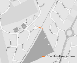
Proposed Royston rail crossing
|
|
| Location | Hertfordshire |
|---|---|
| Proposer | Hertfordshire County Council |
| Cost estimate | £3.25m |
| Geometry | KML |
Royston is a city and civil parish in the District of North Hertfordshire and county of Hertfordshire in England.
It is situated on the Greenwich Meridian, which brushes the town's eastern boundary, and at the northernmost apex of the county on the same latitude as towns such as Milton Keynes and Ipswich. It is located 43 miles (69 km) north of central London in a rural area.
Before the boundary changes of the 1890s, the boundary between Hertfordshire and Cambridgeshire ran east–west through the centre of town along the middle of Melbourn Street. The town has a population of 15,781.
The town grew at the crossing of two ancient thoroughfares, Ermine Street and the Icknield Way (cum Ashwell Street); the former was created after the Roman conquest, while the Icknield Way has long been accepted as a prehistoric routeway. The roads are sometimes called military roads as they were prepared or improved by Roman soldiers to facilitate access to the hinterland of Roman Britain. The modern equivalent to Icknield Way is the A505 which bypasses the town to the north. The A10 follows the alignment of Ermine Street south of the town, but diverts before it reaches the crossroads. The A1198, known as the Old North Road follows the alignment of Ermine Street northwards. Barrows on Goffers Knoll and Therfield Heath are evidence of prehistoric settlement.
...
Wikipedia

