Starbuck, Minnesota
| Starbuck, Minnesota | |
|---|---|
| City | |

Starbuck, Minnesota
|
|
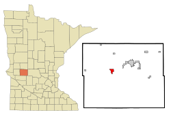
 Location of Starbuck, Minnesota |
|
| Coordinates: 45°36′50″N 95°31′50″W / 45.61389°N 95.53056°W | |
| Country | United States |
| State | Minnesota |
| County | Pope |
| Area | |
| • Total | 1.57 sq mi (4.07 km2) |
| • Land | 1.57 sq mi (4.07 km2) |
| • Water | 0 sq mi (0 km2) |
| Elevation | 1,171 ft (357 m) |
| Population (2010) | |
| • Total | 1,302 |
| • Estimate (2012) | 1,274 |
| • Density | 829.3/sq mi (320.2/km2) |
| Time zone | Central (CST) (UTC-6) |
| • Summer (DST) | CDT (UTC-5) |
| ZIP code | 56381 |
| Area code(s) | 320 |
| FIPS code | 27-62500 |
| GNIS feature ID | 0652561 |
Starbuck is a city in Pope County, Minnesota, United States. The population was 1,302 at the 2010 census. The city is located next to the western shore of Lake Minnewaska.
Minnesota State Highways 28, 29, and 114 are three of the main routes in the city.
According to the United States Census Bureau, the city has a total area of 1.57 square miles (4.07 km2), all of it land.
Starbuck was platted in the spring of 1882, is a village of the Northern Pacific railway, adjoining the western end of Lake Minnewaska. The growth and settlement of Pope County were greatly retarded for many years by the lack of railway and shipping facilities, which obliged the settlers to go long distances, into adjoining counties, to market their products.
Reportedly the town was named after Stabekk in Bærum in Akershus county, Norway. However, according to Geographical Names of Manitoba, the village of Starbuck in that Canadian province is thought to have been named after the town in Minnesota by a contractor working for the Canadian Pacific Railway in 1885. It states that Starbuck, Minnesota, was named after William H. Starbuck of New York and who financed the Little Falls and Dakota Railroad.
As of the census of 2010, there were 1,302 people, 576 households, and 328 families residing in the city. The population density was 829.3 inhabitants per square mile (320.2/km2). There were 671 housing units at an average density of 427.4 per square mile (165.0/km2). The racial makeup of the city was 97.3% White, 0.3% African American, 0.3% Native American, 0.8% from other races, and 1.3% from two or more races. Hispanic or Latino of any race were 1.3% of the population.
...
Wikipedia
