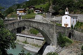
Stalden VS
| Stalden | ||
|---|---|---|
 |
||
|
||
| Coordinates: 46°14′N 7°52′E / 46.233°N 7.867°ECoordinates: 46°14′N 7°52′E / 46.233°N 7.867°E | ||
| Country | Switzerland | |
| Canton | Valais | |
| District | Visp | |
| Government | ||
| • Mayor | Egon Furrer | |
| Area | ||
| • Total | 10.43 km2 (4.03 sq mi) | |
| Elevation | 795 m (2,608 ft) | |
| Population (Dec 2016) | ||
| • Total | 1,119 | |
| • Density | 110/km2 (280/sq mi) | |
| Postal code | 3922 | |
| SFOS number | 6293 | |
| Surrounded by | Eisten, Grächen, Staldenried, Törbel, Visperterminen, Zeneggen | |
| Website |
www SFSO statistics |
|
Stalden is a municipality in the district of Visp in the canton of Valais in Switzerland. It lies at the foot of the Mischabelhörner and Dom (4,545 m [14,911 ft]).
Stalden is first mentioned in 1213 as Morgi. In 1224 it was mentioned as Staldun.
Stalden has an area, as of 2011[update], of 10.5 square kilometers (4.1 sq mi). Of this area, 10.0% is used for agricultural purposes, while 71.9% is forested. Of the rest of the land, 6.4% is settled (buildings or roads) and 11.7% is unproductive land.
The municipality is located in the Visp district, at the branching of the Matter and Saas valleys. It consists of three formerly independent villages Stalden Dorfmark, Chinegga (since 1805) and Niederrusen (since 1817, now called Neubrück).
The blazon of the municipal coat of arms is Gules, two Lions rampant regaurdant Or both holding a Sword Argent on Coupeaux Vert.
Stalden has a population (as of December 2016[update]) of 1,119. As of 2008[update], 4.2% of the population are resident foreign nationals. Over the last 10 years (2000–2010 ) the population has changed at a rate of -9.8%. It has changed at a rate of -8.9% due to migration and at a rate of -0.6% due to births and deaths.
Most of the population (as of 2000[update]) speaks German (1,118 or 97.3%) as their first language, Albanian is the second most common (9 or 0.8%) and Italian is the third (7 or 0.6%). There are 6 people who speak French.
...
Wikipedia


