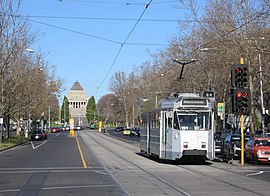
St Kilda Road, Melbourne
|
St Kilda Road Victoria |
|
|---|---|
 |
|
| Looking away from the City towards the Shrine of Remembrance | |
| Type | Street |
| Length | 6 km (3.7 mi) |
| Route number(s) |
|
| Northwest end | Flinders Street, Melbourne |
|
|
| Southeast end | Brighton Road and Carlisle Street, St Kilda |
| Suburb(s) | Southbank, Melbourne 3004 |
St Kilda Road is a street in Melbourne, Victoria, Australia. It is part of the locality of Melbourne which has the postcode of 3004 and along with Swanston Street forms a major spine of the city.
St Kilda Road begins at Flinders Street, in the central business district and crosses Princes Bridge, which spans the Yarra River and connects the central business district of Melbourne with the suburb of St Kilda, ending at Carlisle Street, St Kilda. The road continues as Brighton Road, which becomes Nepean Highway, forming a major arterial connecting the bayside suburbs and Mornington Peninsula to the city.
The east side of the road to High Street, Prahran is in the municipality of the City of Melbourne while the west side of the road and the road south of High Street is in the municipality of the City of Port Phillip.
The first sale of Crown lands in St. Kilda took place on 7 December 1842. Within a few years, St Kilda became a fashionable area for wealthy settlers, with the high ground above the beach offering a cool fresh breeze during Melbourne's hot summer months. St Kilda Road was a dirt track that linked St Kilda to the town centre. The road was impassable by carriage after rains, which turned the road to mud. Prior to the building of the first bridge spanning the Yarra River in 1844, traffic crossed the river by privately operated punts. In 1844, a privately built wooden trestle toll bridge was built across the river at Swanston Street.
...
Wikipedia
