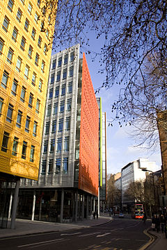
St Giles High Street
| St Giles | |
|---|---|
 St Giles High Street, January 2012 |
|
| St Giles shown within Greater London | |
| OS grid reference | TQ300811 |
| • Charing Cross | 0.5 mi (0.8 km) S |
| London borough | |
| Ceremonial county | Greater London |
| Region | |
| Country | England |
| Sovereign state | United Kingdom |
| Post town | LONDON |
| Postcode district | WC1, WC2 |
| Dialling code | 020 |
| Police | Metropolitan |
| Fire | London |
| Ambulance | London |
| EU Parliament | London |
| UK Parliament | |
| London Assembly | |
St Giles is a district of London, at the southern tip of the London Borough of Camden. It was formerly the parish of St Giles in the Fields and the combined parishes of St Giles in the Fields and St George Bloomsbury formed the St Giles District of the Metropolis from 1855 to 1900. It is the location of the church of St Giles in the Fields, the Phoenix Garden and St Giles Circus. With Bloomsbury and Holborn, it is part of the "Midtown" business improvement district.
There has been a church at St Giles since Saxon times, located beside a major highway.The hospital of St Giles, recorded c. 1120 as Hospitali Sancti Egidii extra Londonium was founded, together with a monastery and a chapel, by Queen Matilda, wife of Henry I.St Giles (c. 650 – c. 710) was the patron saint of lepers and the hospital was home to a leper colony, the site chosen for its surrounding fields and marshes separating contagion from nearby London. Peter Ackroyd argues that the character of vagrancy has never left the area.A village accreted to cater to the brethren and patients. The crossroads which is now St. Giles Circus, where Oxford Street, Charing Cross Road, Tottenham Court Road and New Oxford St meet, was the site of a gallows until the fifteenth century. Grape Street, in the heart of the St Giles district, runs beside the site of the hospital's vineyard.
The monastery was dissolved during the Reformation and a parish church created from the chapel. The hospital continued to care for lepers until the mid sixteenth century, when the disease abated and the hospital instead began to care for indigents. The parish was known as St Giles in the Fields and it is recorded in 1563 as Seynt Gyles in the Field. The first post-Catholic parish church was built in 1631 and from the mid-seventeenth century church wardens note "a great influx of poor people into this parish". The cellars in particular were already recorded as horrific places in which whole families resided, "damp and unwholesome" as the village was built on marshland. The Parliamentary Act of 1606 had condemned the area as "deepe foul and dangerous" . Vagrants expelled from the city settled in the St Giles district known for the generous charitable relief of the parish. Irish and French refugees were drawn to the area as well as "St Giles blackbirds", black servants reduced to begging.
...
Wikipedia

