Holborn
| Holborn | |
|---|---|
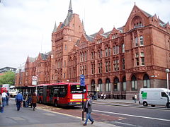
 Holborn Bars, built 1879–1901, headquarters of Prudential Assurance, at 138–142 Holborn |
|
| Holborn shown within Greater London | |
| Population | 13,023 (2011 Census. Holborn and Covent Garden Ward) |
| OS grid reference | TQ305815 |
| London borough | |
| Ceremonial county | Greater London |
| Region | |
| Country | England |
| Sovereign state | United Kingdom |
| Post town | LONDON |
| Postcode district | WC1, WC2 |
| Postcode district | EC1 |
| Dialling code | 020 |
| Police | Metropolitan |
| Fire | London |
| Ambulance | London |
| EU Parliament | London |
| UK Parliament | |
| London Assembly | |
Holborn (/ˈhoʊbərn/ HOH-bə(r)n) is a district in the West End, central London, forming part of the London Borough of Camden.
The area's first mention is in a charter of Westminster Abbey, by King Edgar, dated to 959. This mentions "the old wooden church of St Andrew" (St Andrew, Holborn). The name Holborn may be derived from the Middle English "hol" for hollow, and bourne, a brook, referring to the River Fleet as it ran through a steep valley to the east. Historical cartographer William Shepherd in his Plan of London about 1300 labels the Fleet as "Hole Bourn" where it passes to the east of St Andrew's church. However, the 16th century historian John Stow attributes the name to the Old Bourne ("old brook"), a small stream which he believed ran into the Fleet at Holborn Bridge, a structure lost when the river was culverted in 1732. The exact course of the stream is uncertain, but according to Stow it started in one of the many small springs near Holborn Bar, the old City toll gate on the summit of Holborn Hill. This is supported by a map of London and Westminster created during the reign of Henry VIII that clearly marks the street as 'Oldbourne' and 'High Oldbourne'. Other historians, however, find the theory implausible, in view of the slope of the land.
...
Wikipedia

