St Albans City and District
| City of St Albans | |||
|---|---|---|---|
| Non-metropolitan district, Borough, City | |||

|
|||
|
|||
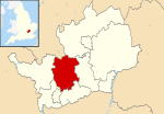
 St Albans shown within Hertfordshire |
|||
| Sovereign state | United Kingdom | ||
| Constituent country | England | ||
| Region | East of England | ||
| Non-metropolitan county | Hertfordshire | ||
| Status | Non-metropolitan district, Borough, City | ||
| Admin HQ | St Albans | ||
| Incorporated | 1 April 1974 | ||
| Government | |||
| • Type | Non-metropolitan district council | ||
| • Body | St Albans City and District Council | ||
| • Leadership | Leader & Cabinet | ||
| • MPs |
Anne Main Bim Afolami |
||
| Area | |||
| • Total | 62.23 sq mi (161.18 km2) | ||
| Area rank | (of 326) | ||
| Population (mid-2016 est.) | |||
| • Rank | (of 326) | ||
| • Ethnicity | 90.9% White 4.1% S.Asian 1.7% Black 1.9% Mixed Race 1.4% Chinese or Other |
||
| Time zone | GMT (UTC0) | ||
| • Summer (DST) | BST (UTC+1) | ||
| ONS code | 26UG (ONS) E07000100 (GSS) |
||
| OS grid reference | TL148073 | ||
| Website | www |
||
St Albans City and District (/sɪnt ˈɔːlbənz/) is a local authority district in Hertfordshire in the East of England region. The main urban settlements are St Albans and Harpenden. The council offices are in St Albans.
St Albans City and District is a non-metropolitan district and city created on 1 April 1974 as a merger of the Municipal Borough of St Albans, the Harpenden Urban District and most of St Albans Rural District. The municipal borough had had city status since 1877 and it was granted to the entire district by letters patent on 9 July 1974.
The district is in the west of Hertfordshire, bounded on the north west by Luton, on the north east by North Hertfordshire, on the east by Welwyn Hatfield, on the south by Hertsmere, on the south west by Watford and Three Rivers and on the west by Dacorum. The largest urban settlement is St Albans, followed in size by Harpenden, with lesser settlements at Redbourn, Wheathamstead, London Colney, Chiswell Green and Bricket Wood. Nearby towns include Hatfield to the east, Welwyn Garden City to the northeast, Luton and Dunstable to the northwest, Hemel Hempstead to the west, Watford to the southwest and Borehamwood to the south.
...
Wikipedia


