St. Peter, Minnesota
| St. Peter, Minnesota | |
|---|---|
| City | |

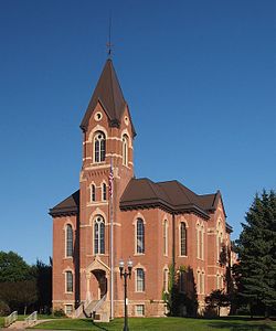
Nicollet County Courthouse in St. Peter
|
|
| Motto: "Where History & Progress Meet" | |
 Location of the city of St. Peter within Nicollet County in the state of Minnesota |
|
| Coordinates: 44°20′00″N 93°58′00″W / 44.33333°N 93.96667°W | |
| Country | United States |
| State | Minnesota |
| County | Nicollet |
| City | 1873 |
| Government | |
| • Type | Mayor–Council |
| • Mayor | Chuck Zieman |
| Area | |
| • Total | 5.77 sq mi (14.94 km2) |
| • Land | 5.59 sq mi (14.48 km2) |
| • Water | 0.18 sq mi (0.47 km2) |
| Elevation | 768 ft (234 m) |
| Population (2010) | |
| • Total | 11,196 |
| • Estimate (2015) | 11,666 |
| • Density | 2,002.9/sq mi (773.3/km2) |
| Time zone | Central (CST) (UTC-6) |
| • Summer (DST) | CDT (UTC-5) |
| ZIP code | 56082 |
| Area code(s) | 507 |
| FIPS code | 27-58036 |
| GNIS feature ID | 0651004 |
| Website | City of St. Peter |
St. Peter is a city located in Nicollet County, Minnesota, United States. The city is located 10 miles north of the Mankato – North Mankato metropolitan area. The population was 11,196 at the 2010 census. It is the county seat of Nicollet County. Saint Peter is the home of Gustavus Adolphus College.
U.S. Highway 169 and Minnesota State Highways 22 and 99 are three of the main routes in the city.
St. Peter Sister City: Petatlán, Guerrero, Mexico
According to the United States Census Bureau, the city has a total area of 5.77 square miles (14.94 km2), of which 5.59 square miles (14.48 km2) is land and 0.18 square miles (0.47 km2) is water.
As of the census of 2010, there were 11,196 people, 3,491 households, and 2,150 families residing in the city. The population density was 2,002.9 inhabitants per square mile (773.3/km2). There were 3,697 housing units at an average density of 661.4 per square mile (255.4/km2). The racial makeup of the city was 90.1% White, 3.3% African American, 0.6% Native American, 1.6% Asian, 2.3% from other races, and 2.0% from two or more races. Hispanic or Latino of any race were 6.4% of the population.
...
Wikipedia
