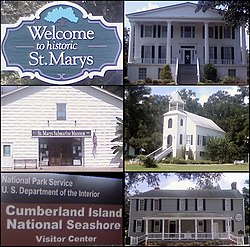
St. Mary's, Georgia
| St. Marys, Georgia | |
|---|---|
| City | |
 |
|
 Location in Camden County and the state of Georgia |
|
| Coordinates: 30°45′23″N 81°34′17″W / 30.75639°N 81.57139°WCoordinates: 30°45′23″N 81°34′17″W / 30.75639°N 81.57139°W | |
| Country | United States of America |
| State | Georgia |
| County | Camden |
| Area | |
| • Total | 24.9 sq mi (64.5 km2) |
| • Land | 22.5 sq mi (58.3 km2) |
| • Water | 2.4 sq mi (6.2 km2) |
| Elevation | 10 ft (3 m) |
| Population (2010) | |
| • Total | 17,121 |
| • Density | 761/sq mi (293.7/km2) |
| Time zone | Eastern (EST) (UTC-5) |
| • Summer (DST) | EDT (UTC-4) |
| FIPS code | 13-67984 |
| GNIS feature ID | 0356510 |
| Website | www |
St. Marys is a city in Camden County, Georgia, United States. The city is the gateway to Cumberland Island National Seashore, the largest of the Georgia Coast's barrier islands. The National Seashore's visitor center and boat access are both located at the St. Marys waterfront. The city is also home to the annual St. Marys Rock Shrimp Festival, the St. Marys Submarine Museum, the Kings Bay Naval Submarine Base, and to eight Ohio-class submarines. The population of St. Marys was 17,121 at the 2010 census.
St. Marys is located along the southern border of Camden County at 30°45′23″N 81°34′17″W / 30.75639°N 81.57139°W (30.756264, -81.571287), on the north bank of the St. Marys River. The state of Florida is to the south, across the river. The city of Kingsland borders St. Marys to the west.
According to the United States Census Bureau, St. Marys has a total area of 24.9 square miles (64.5 km2), of which 22.5 square miles (58.3 km2) is land and 2.4 square miles (6.2 km2), or 9.57%, is water.
The closest major city is Jacksonville, Florida, 38 miles (61 km) south.
...
Wikipedia
