St. Johns, Saba
| St. Johns | |
|---|---|
| Village | |

View of St Johns Village as seen from Mount Scenery
|
|
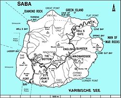
 Map of Saba showing St. Johns |
|
| Coordinates: 17°37′13.36″N 63°14′35.1″W / 17.6203778°N 63.243083°WCoordinates: 17°37′13.36″N 63°14′35.1″W / 17.6203778°N 63.243083°W | |
| Country |
|
| Public body |
|
| Population | |
| • Total | 186 |
| Time zone | AST (UTC-4) |
St. Johns is the smallest settlement on Saba and is located between The Bottom and Windwardside.
St. Johns is primarily a residential area, but also contains both schools on the island, the Sacred Heart School (primary education) and Saba Comprehensive School (secondary education).
Attached to the Sacred Heart School is a small chapel that is run by Father Janssen. It is common to see the chapel used by the school on weekdays for religious class and on Sunday for mass.
...
Wikipedia
