St. John, Washington
| St. John | |
|---|---|
| Town | |
| St. John, Washington | |
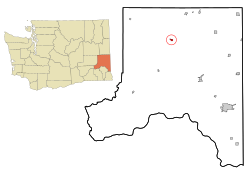
 Location of St. John, Washington |
|
| Coordinates: 47°5′25″N 117°34′56″W / 47.09028°N 117.58222°WCoordinates: 47°5′25″N 117°34′56″W / 47.09028°N 117.58222°W | |
| Country | United States |
| State | Washington |
| County | Whitman |
| Area | |
| • Total | 0.63 sq mi (1.63 km2) |
| • Land | 0.63 sq mi (1.63 km2) |
| • Water | 0 sq mi (0 km2) |
| Elevation | 1,962 ft (598 m) |
| Population (2010) | |
| • Total | 537 |
| • Estimate (2015) | 552 |
| • Density | 852.4/sq mi (329.1/km2) |
| Time zone | Pacific (PST) (UTC-8) |
| • Summer (DST) | PDT (UTC-7) |
| ZIP code | 99171 |
| Area code(s) | 509 |
| FIPS code | 53-60860 |
| GNIS feature ID | 1508016 |
| Website | Town of St. John |
St. John is a town in Whitman County, Washington, United States. The population was 537 at the 2010 census. St. John is the birthplace of the twentieth governor of Washington, Mike Lowry.
St. John was founded and named in the late 1880s for settler E.T. St. John. St. John was officially incorporated on March 10, 1904.
St. John is located at 47°05′25″N 117°34′56″W / 47.090403°N 117.582085°W (47.090403, -117.582085).
According to the United States Census Bureau, the town has a total area of 0.63 square miles (1.63 km2), all of it land.
St. John's climate is classified as warm-summer Mediterranean climate (Csb) according to the Köppen climate classification system, but nearly qualifies as a dry-summer humid continental climate due to its cold winter months.
As of the census of 2010, there were 537 people, 261 households, and 145 families residing in the town. The population density was 852.4 inhabitants per square mile (329.1/km2). There were 304 housing units at an average density of 482.5 per square mile (186.3/km2). The racial makeup of the town was 94.6% White, 0.2% African American, 0.4% Native American, 0.2% Asian, 0.4% Pacific Islander, 0.4% from other races, and 3.9% from two or more races. Hispanic or Latino of any race were 1.9% of the population.
...
Wikipedia
