St. James, Minnesota
| St. James, Minnesota | |
|---|---|
| City | |

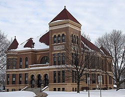
The Watonwan County Courthouse in St. James
|
|
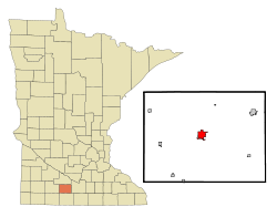
 Location of St. James within Watonwan County and state of Minnesota |
|
| Coordinates: 43°58′56″N 94°37′41″W / 43.98222°N 94.62806°WCoordinates: 43°58′56″N 94°37′41″W / 43.98222°N 94.62806°W | |
| Country | United States |
| State | Minnesota |
| County | Watonwan |
| Government | |
| • Type | Mayor – Council |
| • Mayor | Gary Sturm |
| Area | |
| • Total | 2.43 sq mi (6.29 km2) |
| • Land | 2.40 sq mi (6.22 km2) |
| • Water | 0.03 sq mi (0.08 km2) |
| Elevation | 1,079 ft (329 m) |
| Population (2010) | |
| • Total | 4,605 |
| • Estimate (2012) | 4,587 |
| • Density | 1,918.8/sq mi (740.9/km2) |
| Time zone | Central (CST) (UTC-6) |
| • Summer (DST) | CDT (UTC-5) |
| FIPS code | 27-57040 |
| GNIS feature ID | 0650613 |
| Website | www.ci.stjames.mn.us |
St. James is a city in and the county seat of Watonwan County, Minnesota, United States. The population was 4,605 at the 2010 census.
Minnesota State Highways 4, 30, and 60 are three of the main routes in the city.
In 1870, the directors of the St. Paul and Sioux City railroads chose the future townsite of St. James as the midpoint for a new railroad linking the two cities. Named for James Purington, an early settler, the new city was incorporated in 1871. It was the hometown of Minnesota Governor Winfield Scott Hammond, a Democrat who served in 1915. In the 1940s, Theodore S. Mondale, the father of future Vice President of the United States Walter Mondale, was the pastor at First Methodist Church of St. James. Tony Downs Foods Co. has been a major employer since 1947, processing poultry and frozen meals.
According to the United States Census Bureau, the city has a total area of 2.43 square miles (6.29 km2); 2.40 square miles (6.22 km2) is land and 0.03 square miles (0.08 km2) is water.
As of the census of 2010, there were 4,605 people, 1,839 households, and 1,145 families residing in the city. The population density was 1,918.8 inhabitants per square mile (740.9/km2). There were 2,039 housing units at an average density of 849.6 per square mile (328.0/km2). The racial makeup of the city was 81.8% White, 0.7% African American, 0.9% Native American, 0.6% Asian, 14.9% from other races, and 1.1% from two or more races. Hispanic or Latino of any race were 31.0% of the population.
...
Wikipedia
