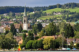
Stäfa
| Stäfa | ||
|---|---|---|
 |
||
|
||
| Coordinates: 47°14′N 8°43′E / 47.233°N 8.717°ECoordinates: 47°14′N 8°43′E / 47.233°N 8.717°E | ||
| Country | Switzerland | |
| Canton | Zurich | |
| District | Meilen | |
| Area | ||
| • Total | 8.58 km2 (3.31 sq mi) | |
| Elevation | 408 m (1,339 ft) | |
| Population (Dec 2015) | ||
| • Total | 14,152 | |
| • Density | 1,600/km2 (4,300/sq mi) | |
| Postal code | 8712 | |
| SFOS number | 0158 | |
| Surrounded by | Freienbach (SZ), Hombrechtikon, Männedorf, Oetwil am See, Richterswil, Wädenswil | |
| Website |
www SFSO statistics |
|
Stäfa is a municipality in the district of Meilen in the canton of Zürich in Switzerland.
Stäfa has an area of 8.6 km2 (3.3 sq mi). Of this area, 46.1% is used for agricultural purposes, while 18.8% is forested. Of the rest of the land, 34% is settled (buildings or roads) and the remainder (1%) is non-productive (rivers, glaciers or mountains). In 1996[update] housing and buildings made up 26.7% of the total area, while transportation infrastructure made up the rest (7.2%). Of the total unproductive area, water (streams and lakes) made up 0.5% of the area. As of 2007[update] 35.8% of the total municipal area was undergoing some type of construction.
It is located near Rapperswil on the north bank of the Lake Zürich in the Pfannenstiel region.
In the local dialect it is called Stäfa.
The villages of Kehlhof and Uerikon are politically part of the town. Stäfa is linked with the German poet Goethe who once stayed overnight in the town. It was named after the Scottish island of Staffa by a monk from Iona.
Stäfa has a population (as of 31 December 2015) of 14,152. As of 2007[update], 16.0% of the population was made up of foreign nationals. As of 2008[update] the gender distribution of the population was 48.6% male and 51.4% female. Over the last 10 years the population has grown at a rate of 22%. Most of the population (as of 2000[update]) speaks German (88.6%), with Italian being second most common ( 3.3%) and Albanian being third ( 1.4%).
...
Wikipedia


