Sremska Kamenica
|
Sremska Kamenica Сремска Каменица |
||
|---|---|---|
| Town | ||

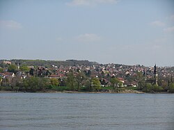
View from the Danube
|
||
|
||
| Location in Serbia | ||
| Coordinates: 45°13′14″N 19°50′21″E / 45.22056°N 19.83917°ECoordinates: 45°13′14″N 19°50′21″E / 45.22056°N 19.83917°E | ||
| Country |
|
|
| District | South Bačka | |
| City | Novi Sad | |
| Municipality | Petrovaradin | |
| Population (2011 census) | 11,967 | |
| Time zone | UTC+1 | |
| Area code(s) | + 381(0)21 | |
Sremska Kamenica (Cyrillic: Сремска Каменица, pronounced [sreɛ̂ːmskaː kâmenit͡sa]) is a town and urban neighborhood of Novi Sad, in Serbia.
In Serbian, the town is known as Sremska Kamenica (Сремска Каменица), in Croatian as Srijemska Kamenica, in Hungarian as Kamanc, and in German as Kamenitz.
The town is located in the Syrmia region, on the northern slopes of the Fruška Gora mountain range and on the river Danube. The Freedom Bridge crosses the River Danube and connects the town with the main part of Novi Sad. Sremska Kamenica and the villages Bukovac, Ledinci and Stari Ledinci, are all part of Petrovaradin urban municipality.
The town is divided into a couple of neighborhoods: Donja Kamenica (Lower Kamenica), Gornja Kamenica (Upper Kamenica), Bocke, Tatarsko Brdo, Čardak, and Staroiriški Put.
The settlements of Paragovo, Popovica, Glavica, and Artinjeva (Artiljevo) are also administratively parts of Sremska Kamenica. These settlements are a weekend retreat for people from Novi Sad into the countryside, because of their location on the edge of Fruška Gora National Park.
...
Wikipedia


