Springtown, Texas
| Springtown, Texas | |
|---|---|
| City | |
 |
|
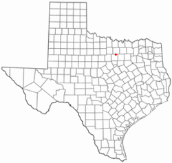
 Location of Springtown, Texas |
|
 |
|
| Coordinates: 32°58′3″N 97°40′57″W / 32.96750°N 97.68250°WCoordinates: 32°58′3″N 97°40′57″W / 32.96750°N 97.68250°W | |
| Country | United States |
| State | Texas |
| County | Parker, Wise |
| Area | |
| • Total | 2.8 sq mi (7.1 km2) |
| • Land | 2.8 sq mi (7.1 km2) |
| • Water | 0.0 sq mi (0.0 km2) |
| Elevation | 860 ft (262 m) |
| Population (2010) | |
| • Total | 2,658 |
| • Density | 950/sq mi (370/km2) |
| Time zone | Central (CST) (UTC-6) |
| • Summer (DST) | CDT (UTC-5) |
| ZIP code | 76082 |
| Area code(s) | 817 |
| FIPS code | 48-69800 |
| GNIS feature ID | 1379105 |
Springtown is a city in Wise and Parker County, Texas, United States. The population was 2,658 at the 2010 census.
Springtown was the site of College Hill Institute. The school was chartered by the State of Texas in 1884. It operated for ten years, and closed in 1894.
Springtown is located at 32°58′3″N 97°40′57″W / 32.96750°N 97.68250°W (32.967500, -97.682599).
According to the United States Census Bureau, the city has a total area of 2.8 square miles (7.3 km2), all of it land.
The climate in this area is characterized by hot, humid summers and generally mild to cool winters. According to the Köppen Climate Classification system, Springtown has a humid subtropical climate, abbreviated "Cfa" on climate maps.
Students are served by the Springtown Independent School District.
As of the census of 2000, there were 2,062 people, 773 households, and 586 families residing in the city. The population density was 747.4 people per square mile (288.5/km²). There were 842 housing units at an average density of 305.2 per square mile (117.8/km²). The racial makeup of the city was 95.68% White, 0.48% African American, 0.34% Native American, 0.19% Asian, 0.19% Pacific Islander, 1.94% from other races, and 1.16% from two or more races. Hispanic or Latino of any race were 3.39% of the population.
...
Wikipedia
