Springfield, Nebraska
| Springfield, Nebraska | |
|---|---|
| City | |

Main Street, Springfield
|
|
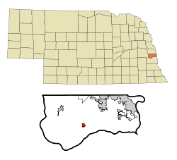
 Location of Springfield, Nebraska |
|
| Coordinates: 41°4′56″N 96°7′57″W / 41.08222°N 96.13250°WCoordinates: 41°4′56″N 96°7′57″W / 41.08222°N 96.13250°W | |
| Country | United States |
| State | Nebraska |
| County | Sarpy |
| Area | |
| • Total | 0.69 sq mi (1.79 km2) |
| • Land | 0.69 sq mi (1.79 km2) |
| • Water | 0 sq mi (0 km2) |
| Elevation | 1,066 ft (325 m) |
| Population (2010) | |
| • Total | 1,529 |
| • Estimate (2016) | 1,604 |
| • Density | 2,200/sq mi (850/km2) |
| Time zone | Central (CST) (UTC-6) |
| • Summer (DST) | CDT (UTC-5) |
| ZIP code | 68059 |
| Area code(s) | 402, 531 |
| FIPS code | 31-46520 |
| GNIS feature ID | 0833737 |
| Website | http://www.SpringfieldNebraska.com/ |
Springfield is a city in Sarpy County, Nebraska, United States. The population was 1,529 at the 2010 census.
Springfield was platted in 1873 by a U.S. civil war veteran named J. D. Sprearman. This was done in anticipation of the coming of the Missouri Pacific Railroad. The town was named from several springs nearby.
Springfield is located at 41°4′56″N 96°7′57″W / 41.08222°N 96.13250°W (41.082245, -96.132431).
According to the United States Census Bureau, the city has a total area of 0.69 square miles (1.79 km2), all of it land.
The nearest hospital is Midlands Hospital (9.1 miles) located in Papillion, Nebraska. Papillion is also the location of the county courthouse.
As of the census of 2010, there were 1,529 people, 575 households, and 423 families residing in the city. The population density was 2,215.9 inhabitants per square mile (855.6/km2). There were 604 housing units at an average density of 875.4 per square mile (338.0/km2). The racial makeup of the city was 95.8% White, 0.7% African American, 0.1% Native American, 0.2% Asian, 0.5% from other races, and 2.7% from two or more races. Hispanic or Latino of any race were 1.8% of the population.
...
Wikipedia
