Spring Glen, Utah
| Spring Glen, Utah | |
|---|---|
| Census-designated place | |

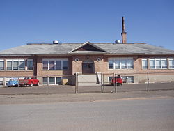
Spring Glen's 1927 schoolhouse
|
|
 Location in Carbon County and the state of Utah |
|
| Coordinates: 39°39′25″N 110°50′56″W / 39.65694°N 110.84889°WCoordinates: 39°39′25″N 110°50′56″W / 39.65694°N 110.84889°W | |
| Country | United States |
| State | Utah |
| County | Carbon |
| Settled | 1878 |
| Founded by | James Gay |
| Area | |
| • Total | 3.4 sq mi (8.8 km2) |
| • Land | 3.4 sq mi (8.8 km2) |
| • Water | 0.0 sq mi (0.0 km2) |
| Elevation | 5,761 ft (1,756 m) |
| Population (2010) | |
| • Total | 1,126 |
| • Density | 330/sq mi (127.4/km2) |
| Time zone | Mountain (MST) (UTC-7) |
| • Summer (DST) | MDT (UTC-6) |
| ZIP code | 84526 |
| Area code(s) | 435 |
| GNIS feature ID | 2584777 |
Spring Glen is a census-designated place in Carbon County, in eastern Utah, United States. The population was 1,126 at the 2010 census. Founded in 1878, Spring Glen was the first permanent settlement in what is now Carbon County. First settled principally by white Mormon farmers, the community became much more diverse after about 1890, when the development of the area's coal mines brought an influx of immigrants from Southern Europe and other regions.
Spring Glen lies along the Price River, just to the south of Helper and southwest of Kenilworth. To the southeast are Carbonville and the county seat, Price. U.S. Route 6 runs past Spring Glen between Price and Helper, and SR-139 branches east from it to become Spring Glen Road, the major street through town. According to the United States Census Bureau, the CDP has a total area of 3.4 square miles (8.8 km2), all of it land.
According to the Köppen Climate Classification system, Spring Glen has a humid continental climate, abbreviated "Dfb" on climate maps. This climatic region is typified by large seasonal temperature differences, with warm to hot (and often humid) summers and cold (sometimes severely cold) winters.
...
Wikipedia
