Spencer, Wisconsin
| Spencer, Wisconsin | |
|---|---|
| Village | |

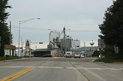
Looking south at downtown Spencer on WIS13 / WIS98
|
|
| Motto: A friendly small town with a future. | |
 Location of Spencer, Wisconsin |
|
| Coordinates: 44°43′53″N 90°16′13″W / 44.73139°N 90.27028°WCoordinates: 44°43′53″N 90°16′13″W / 44.73139°N 90.27028°W | |
| Country | United States |
| State | Wisconsin |
| County | Marathon |
| Area | |
| • Total | 2.01 sq mi (5.21 km2) |
| • Land | 2.01 sq mi (5.21 km2) |
| • Water | 0 sq mi (0 km2) |
| Elevation | 1,312 ft (400 m) |
| Population (2010) | |
| • Total | 1,925 |
| • Estimate (2012) | 1,928 |
| • Density | 957.7/sq mi (369.8/km2) |
| Time zone | Central (CST) (UTC-6) |
| • Summer (DST) | CDT (UTC-5) |
| Area code(s) | 715 & 534 |
| FIPS code | 55-75425 |
| GNIS feature ID | 1584184 |
| Website | vil |
Spencer is a village in the Town of Spencer in Marathon County, Wisconsin. It is part of the Wausau, Wisconsin Metropolitan Statistical Area. The population was 1,925 at the 2010 census.
The village, which lies between two marshes (Spencer Marsh to the northwest and McMillan Marsh to the southeast) was founded in 1874 at a branch on the Wisconsin Central Railway. Today it sits at the crossroads of Wisconsin Highway 13 and 98 and serves as the terminus of several Marathon County trunk highways. Spencer lies about 8 miles (13 km) northwest of Marshfield, along Highway 13.
Spencer was known by the name Waltham. Then the name was changed to Irene, after the wife of James L. Robinson a settler who had built a sawmill here. Later the town was named Spencer, after Spencer, Massachusetts.
Spencer is located at 44°45′23″N 90°17′53″W / 44.756406°N 90.298178°W (44.756406, -90.298178).
According to the United States Census Bureau, the village has a total area of 2.01 square miles (5.21 km2), all of it land.
As of the census of 2010, there were 1,925 people, 816 households, and 540 families residing in the village. The population density was 957.7 inhabitants per square mile (369.8/km2). There were 875 housing units at an average density of 435.3 per square mile (168.1/km2). The racial makeup of the village was 97.4% White, 0.4% Native American, 0.1% Pacific Islander, 1.1% from other races, and 1.1% from two or more races. Hispanic or Latino of any race were 2.0% of the population.
...
Wikipedia
