Special Areas Board
| Special Areas Board | |
|---|---|
| Rural municipality | |

Boundary sign
|
|
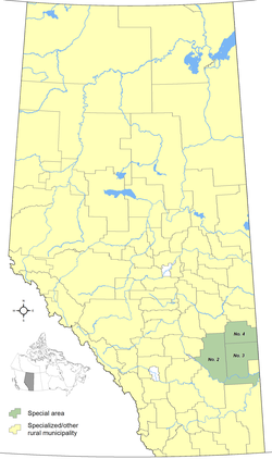
 Distribution of Alberta's three special areas |
|
| Country |
|
| Province |
|
| Regions | Central and Southern Alberta |
| Census division | No. 4 |
| Special Areas Act | 1938 |
| Government | |
| • Governing body | Special Areas Board |
| • Chairperson | Jordon Christianson (acting) |
| • Minister of Municipal Affairs | Deron Bilous |
| • District office | Hanna |
| Area (2011) | |
| • Total | 20,369.41 km2 (7,864.67 sq mi) |
| Population (2011) | |
| • Total | 4,499 |
| • Density | 0.22/km2 (0.6/sq mi) |
| Time zone | MST (UTC-7) |
| • Summer (DST) | MDT (UTC-6) |
| Website | Special Areas Board |
The Special Areas Board is the governing body of Alberta's special areas. Special areas are designated rural municipalities similar to a municipal district, however, the elected advisory councils are overseen by three representatives appointed by the province, under the direct authority of Alberta Municipal Affairs.
The three special areas were created in 1938 under the authority of the Special Areas Act as a result of hardship brought upon a particular area in southeastern Alberta during the drought of the 1930s. A special area is not to be confused with a specialized municipality, which is a completely different municipal status.
The special areas are administered under the provisions of the Special Areas Act. The three special areas are located in southeast Alberta within Census Division 4.
The Special Areas Act of 1938 created the six special areas of Tilley East, Berry Creek, Sullivan Lake, Sounding Creek, Neutral Hills, and Bow West, which had previously been special municipal areas. In 1939, these six special areas were consolidated into the four special areas listed below. The original six special areas included 3.2 million hectares, while the current three only include 2.1 million hectares.
Alberta's three special areas had a combined population totalling 4,499 in 2011.
...
Wikipedia
