Southwest Philadelphia
| Southwest Philadelphia | |
|---|---|
| Neighborhood of Philadelphia | |

|
|
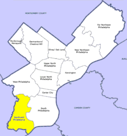
 Southwest Philadelphia, as defined by the Philadelphia City Planning Commission |
|
| Country | |
| State |
|
| County |
|
| City |
|
| Area | |
| • Total | 10.6 sq mi (27 km2) |
| Population (2010) | |
| • Total | 123,829 |
| • Density | 5,192/sq mi (2,005/km2) |
| ZIP code | 19142, 19143, 19153 |
Southwest Philadelphia (formerly Kingsessing Township) is a section of Philadelphia, Pennsylvania, United States. The section can be described as extending from the western side of the Schuylkill River to the city line, with the SEPTA. The northern border is defined by the Philadelphia City Planning Commission as east from the city line along Baltimore Avenue moving south along 51st Street to Springfield Ave. It follows the train tracks until 49th Street. From 49th and Kingsessing Ave the line moves east along Kingsessing Ave. The line then moves south along 46th St to Paschall Ave where it jogs to join Grays Ferry where the line runs to the Schuylkill River.
Southwest Philadelphia is also described by the city as being the area south of Baltimore Avenue; this definition has historical merit as Baltimore Avenue between 49th and 52nd Streets was known as "The Hub of Southwest Philadelphia" at the turn of the 20th century. The Philadelphia Police Department patrols two districts located within Southwest Philadelphia. The two patrol districts serving Southwest Philadelphia are the 12th and 77th districts. Historically home to many Irish American neighborhoods, the section now has a large African American population.
Kingsessing Township was a township in the extreme southwestern portion of the county, roughly encompassing what is now known today as Southwest Philadelphia. It was bounded on the north by Blockley Township; on the east by Mill Creek and Schuylkill River; on the south by Delaware River and Bow Creek; and on the west by Darby Creek and Cobbs Creek. It embraces the site of the old village of Kingsessing. The township contained no other settlements of any size except Maylandville. It was traversed principally by the Darby Road and the road to Lazaretto. Its greatest length, 5 miles (8.0 km); greatest breadth, 2 1⁄2 miles (4.0 km); area, 6,800 acres (28 km2). This was the oldest settled portion of the county of Philadelphia.
...
Wikipedia
