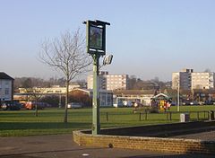
Southcote, Berkshire
| Southcote | |
|---|---|
 Coronation Square in the centre of Southcote |
|
| Southcote shown within Berkshire | |
| Population | 8,548 (2011 census) |
| OS grid reference | SU686719 |
| • London | 38 miles (61 km) East |
| Unitary authority | |
| Shire county | |
| Region | |
| Country | England |
| Sovereign state | United Kingdom |
| Post town | READING |
| Postcode district | RG30 |
| Dialling code | 0118 |
| Police | Thames Valley |
| Fire | Royal Berkshire |
| Ambulance | South Central |
| EU Parliament | South East England |
| UK Parliament | |
Southcote (![]() i/ˈsaʊθkət/) is a suburb of Reading in the English county of Berkshire. Located to the south-west of Reading town centre, Southcote has a population of about 8,500 (as of 2011). The settlement lies primarily between the London-to-Bath road and the River Kennet.
i/ˈsaʊθkət/) is a suburb of Reading in the English county of Berkshire. Located to the south-west of Reading town centre, Southcote has a population of about 8,500 (as of 2011). The settlement lies primarily between the London-to-Bath road and the River Kennet.
The area was sparsely populated until after the Second World War, though excavations have revealed evidence of Paleolithic and Iron Age activity in Southcote, as well as Roman and Saxon habitation. By the time William the Conqueror undertook the Domesday Survey in 1086, Southcote was sufficiently established to warrant a Lord of the Manor, who at that time was William de Braose. From the 16th century onwards, Southcote Manor was owned by the Blagrave family, who sold the manor house in the 1920s. The area was subsequently developed into housing: much of the land changed from agricultural to residential. A large proportion of the land in Southcote not used for housing is classified as flood-meadow, providing flood plains between urbanisation and the River Kennet.
...
Wikipedia

