South Woodbury Township, Pennsylvania
| South Woodbury Township, Pennsylvania | |
|---|---|
| Township | |

|
|
 Map of Bedford County, Pennsylvania highlighting South Woodbury Township |
|
 Map of Bedford County, Pennsylvania |
|
| Country | United States |
| State | Pennsylvania |
| County | Bedford |
| Settled | 1760 |
| Incorporated | 1838 |
| Area | |
| • Total | 33.7 sq mi (87.4 km2) |
| • Land | 33.7 sq mi (87.3 km2) |
| • Water | 0.04 sq mi (0.1 km2) |
| Population (2010) | |
| • Total | 2,155 |
| • Density | 64/sq mi (24.7/km2) |
| Time zone | Eastern (EST) (UTC-5) |
| • Summer (DST) | EDT (UTC-4) |
| Area code(s) | 814 |
South Woodbury Township is a township in Bedford County, Pennsylvania, United States. The population was 2,155 at the 2010 census.
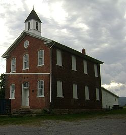
The New Enterprise Public School was listed on the National Register of Historic Places in 1981.
South Woodbury Township is located in northern Bedford County and occupies the southern end of Morrison Cove, a mountain valley. The township's borders follow the ridgecrests of Dunning Mountain on the west, Evitts Mountain on the south, and Tussey Mountain on the east.
According to the United States Census Bureau, the township has a total area of 33.7 square miles (87.4 km2), of which 0.035 square miles (0.09 km2), or 0.10%, is water.
As of the census of 2000, there were 2,000 people, 719 households, and 586 families residing in the township. The population density was 58.6 people per square mile (22.6/km²). There were 762 housing units at an average density of 22.3/sq mi (8.6/km²). The racial makeup of the township was 99.45% White, 0.05% African American, 0.05% Native American, 0.10% Asian, 0.10% from other races, and 0.25% from two or more races. Hispanic or Latino of any race were 0.30% of the population.
...
Wikipedia
