South Park Township, Pennsylvania
| South Park | |
|---|---|
| Township | |
| South Park Township | |

The James Miller House (aka "Stone Manse")
|
|
| Nickname(s): Park | |
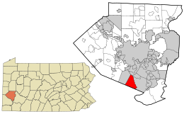
 Location in Allegheny County and state of Pennsylvania |
|
| Coordinates: 40°17′54″N 80°0′8″W / 40.29833°N 80.00222°WCoordinates: 40°17′54″N 80°0′8″W / 40.29833°N 80.00222°W | |
| Country | United States |
| State | Pennsylvania |
| County | Allegheny |
| Area | |
| • Total | 9.2 sq mi (23.8 km2) |
| Population (2010) | |
| • Total | 13,416 |
| • Density | 1,500/sq mi (560/km2) |
| Time zone | Eastern (EST) (UTC-5) |
| • Summer (DST) | EDT (UTC-4) |
South Park Township is a township in the southern part of Allegheny County, Pennsylvania, United States, near Pittsburgh. The population was 13,416 at the 2010 census.
A large portion of the township consists of a county park of the same name [1]. Activities provided in the park include ice skating rinks, tennis courts, a roller hockey rink, a championship golf course, picnic areas, shelters, playgrounds, ballfields, sled riding areas, summer concerts, horse-back riding, walking and biking trails, a very large wave-action swimming pool, and a large dog park.
Composed of portions of St. Clair and Jefferson townships in 1845, South Park was originally called Snowden Township, named after John M. Snowden, a prominent businessman, politician and former Pittsburgh mayor, who had died earlier that year. In the 1930s, Allegheny County acquired several large parcels of farm land mostly within Snowden Township and created a regional recreational area named South Park. The huge success of South Park, and the fact the facility occupies roughly one-third of the community's total area, eventually prompted a 1966 referendum in which the township was renamed.
The area in and around South Park Township was settled in the mid-18th century. It is the location of the Oliver Miller Homestead where in 1794, the first shots of the Whiskey Rebellion were fired. A log house was originally built on the site in 1772; it was replaced by a stone structure around 1830, which is open for public tours.
South Park is located at 40°17′54″N 80°0′7″W / 40.29833°N 80.00194°W (40.298382, -80.002097). South Park's zip code is 15129. According to the United States Census Bureau, the township has a total area of 9.2 square miles (23.8 km²). Negligible area is covered by streams and creeks, most notably Peters Creek. South Park, a 1,999-acre (809 ha) recreational area operated by Allegheny County, is located mostly within the boundaries of South Park Township, although a portion is located in adjacent Bethel Park.
...
Wikipedia
