South Hill, Virginia
| South Hill, Virginia | |
|---|---|
| Town | |

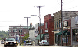
Route 1 in downtown South Hill
|
|
 Location of South Hill, Virginia |
|
| Coordinates: 36°43′36″N 78°7′50″W / 36.72667°N 78.13056°WCoordinates: 36°43′36″N 78°7′50″W / 36.72667°N 78.13056°W | |
| Country | United States |
| State | Virginia |
| County | Mecklenburg |
| Area | |
| • Total | 9.31 sq mi (16.4 km2) |
| • Land | 9.31 sq mi (16.4 km2) |
| • Water | 0.0 sq mi (0.1 km2) |
| Elevation | 466 ft (142 m) |
| Population (2015) | |
| • Total | 4,541 |
| • Density | 696.2/sq mi (268.8/km2) |
| Time zone | Eastern (EST) (UTC-5) |
| • Summer (DST) | EDT (UTC-4) |
| ZIP code | 23970 |
| Area code(s) | 434 |
| FIPS code | 51-73904 |
| GNIS feature ID | 1484872 |
| Website | http://www.southhillva.org/ |
South Hill is a town in Mecklenburg County, Virginia, United States. As of the 2015 census, total population was 4,541. Located on major Interstate and U.S. highways, it has a full-service hospital (serving patients from several rural counties), a tobacco market, and several hotels, and the SouthSide Mall. South Hill has a close relationship with the neighboring town of La Crosse. Lake Gaston, a large reservoir popular with boaters and fishermen, is a short distance to the southwest.
The Colonial Theatre was listed on the National Register of Historic Places in 2003.
South Hill is located at 36°43′36″N 78°7′50″W / 36.72667°N 78.13056°W (36.726759, -78.130597).
The town has a total area of 9.31 square miles (16.4 km²), of which 9.27 square miles (16.4 km²) is land and 0.04 square mile (0.1 km²) (0.47%) is water.
As of the census of 2010, there were 4,650 people, 3,489 households, and 2,231 families residing in the town. The population density was 890.4 people per square mile (503..3/km²). The racial makeup of the town was 56.3% White, 39.4% African American, 0.3% Native American, 1.3% Asian, 1.1% from other races, and 1.6% from two or more races. Hispanic or Latino of any race were 2.5% of the population.
...
Wikipedia
