South Haven, Minnesota
| South Haven, Minnesota | |
|---|---|
| City | |

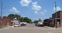
Downtown South Haven
|
|
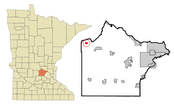
 Location of South Haven within Wright County, Minnesota |
|
| Coordinates: 45°17′30″N 94°12′56″W / 45.29167°N 94.21556°W | |
| Country | United States |
| State | Minnesota |
| County | Wright |
| Area | |
| • Total | 0.63 sq mi (1.63 km2) |
| • Land | 0.63 sq mi (1.63 km2) |
| • Water | 0 sq mi (0 km2) |
| Elevation | 1,109 ft (338 m) |
| Population (2010) | |
| • Total | 187 |
| • Estimate (2012) | 190 |
| • Density | 296.8/sq mi (114.6/km2) |
| Time zone | Central (CST) (UTC-6) |
| • Summer (DST) | CDT (UTC-5) |
| ZIP code | 55382 |
| Area code(s) | 320 |
| FIPS code | 27-61402 |
| GNIS feature ID | 0652314 |
South Haven is a city in Wright County, Minnesota, United States. The population was 187 at the 2010 census.
South Haven was platted in 1888 when the railroad was extended to that point. The city was so named for the fact it is located in Southside Township and due south of Fair Haven Township, Stearns County, Minnesota. A post office has been in operation at South Haven since 1887. South Haven was incorporated in 1902.
According to the United States Census Bureau, the city has a total area of 0.63 square miles (1.63 km2), all of it land. South Haven is located in the northwest part of Wright County.
Minnesota State Highways 24 / 55 (co-signed) serve as a main route in the community. Nearby places include Annandale, Maple Lake, and Kimball.
As of the census of 2010, there were 187 people, 70 households, and 48 families residing in the city. The population density was 296.8 inhabitants per square mile (114.6/km2). There were 74 housing units at an average density of 117.5 per square mile (45.4/km2). The racial makeup of the city was 93.6% White, 0.5% African American, 1.1% Native American, 0.5% Asian, 0.5% from other races, and 3.7% from two or more races. Hispanic or Latino of any race were 4.8% of the population.
...
Wikipedia
