South Eastern Freeway
|
South Eastern Freeway South Australia |
|
|---|---|
 |
|
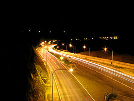
| The highway viewed near the eastern portal of the Heysen Tunnels | |
| Type | Freeway |
| Length | 76 km (47 mi) |
| Opened | 1967 |
| Route number(s) |
|
| Former route number |
|
| West end |
|
|
|
| East end |
|
| Major suburbs / towns | Crafers, Adelaide, Stirling, Bridgewater, Hahndorf, Mount Barker, Callington, Monarto |
|
Highways in Australia National Highway • Freeways in Australia Highways in South Australia |
|
The South Eastern Freeway (previously signposted as Princes Highway) is a 76 kilometre controlled-access highway in South Australia. It carries traffic over the Adelaide Hills between Adelaide and the River Murray, near Murray Bridge, connecting via the Swanport Bridge to the Dukes Highway which is the main road route to Victoria. It is often referred to by South Australians simply as the Freeway, as it was the first freeway in South Australia, and is still the longest, and the only one with "Freeway" in its name rather than "Expressway" or "Highway". It is a part of the National Highway network linking the state capital cities Adelaide to Melbourne and signed as National Highway M1. The South Eastern Freeway includes 500-metre-long twin-tube tunnels (the Heysen Tunnels) in the descent towards Adelaide, the first of their kind on the National Highway. It is designated as the M1.
The South Eastern Freeway features 6 lanes of traffic, arrester beds and concrete median barriers, with street lighting between Glen Osmond and Crafers. The remainder of the length to the Swanport Bridge is dual carriageways with two lanes in each direction.
Prior to the initial construction of the freeway in the 1960s, all inbound and outbound road traffic between Adelaide and south-eastern South Australia and Victoria had to travel on a two-lane highway originally built in the early part of the 20th century. With growth in Adelaide's population issues of congestion and safety mandated reconstruction. Studies began in 1962 for a freeway commencing from Crafers, that endpoint selected arguably due to the massive expenditure required with the precedent upgrade of the Mount Barker Road.
...
Wikipedia
