South Broadway, Cleveland
| Broadway–Slavic Village | |
|---|---|
| Neighborhoods of Cleveland | |
 |
|
 |
|
| Country | United States |
| State | Ohio |
| County | Cuyahoga County |
| City | Cleveland |
| Population (2010) | |
| • Total | 22,432 |
| Demographics | |
| • White | 41% |
| • Black | 52% |
| • Hispanic | 5% |
| • Asian/other | 2% |
| Time zone | EST (UTC-5) |
| • Summer (DST) | EDT (UTC-4) |
| ZIP Codes | 44105, 44127 |
| Area code(s) | 216 |
| Median income | $26,304 |
|
Source: 2010 U.S. Census, City Planning Commission of Cleveland |
|
|
Warszawa Neighborhood District
|
|
| Location | Cleveland, Ohio |
| Coordinates | 41°27′29″N 81°38′41″W / 41.45806°N 81.64472°WCoordinates: 41°27′29″N 81°38′41″W / 41.45806°N 81.64472°W |
| Built | 1880 |
| Architect | Multiple |
| Architectural style | Queen Anne, Other |
| NRHP reference # | 80002980 |
| Added to NRHP | November 28, 1980 |
Source: 2010 U.S. Census, City Planning Commission of Cleveland
Broadway–Slavic Village is a neighborhood on the southeast side of Cleveland, Ohio. One of the city's oldest neighborhoods, it originated as the township of Newburgh, first settled in 1799. Much of the area has historically served as home to Cleveland's original Czech and Polish immigrants. While demographics have shifted over the decades, the largest part of Broadway today, Slavic Village, is named for these earlier communities.
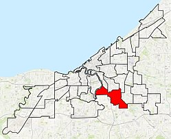
Broadway is bordered to the west and northwest by Cuyahoga Valley, to the north by the Central neighborhood, to the east by the neighborhoods of Union–Miles Park and Kinsman, the suburbs of Cuyahoga Heights and Newburgh Heights to the west and southwest and Garfield Heights to the south.
The historic Slavic Village is named for what was once a predominantly Central European neighborhood centered on Fleet Avenue and Broadway. The neighborhood's name encompasses two smaller ethnically sub-divided sections: the larger Czech-dominated Karlin, and the heavily Polish Warszawa districts.
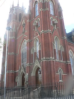
Slavic Village is combining the Warszawa site the Polish immigrants settled in 1870. The lives of these immigrants were centered on the hamlets they've formed and the St. Stanislaus Church they built. Its exact location is at East 65th Street and Forman Avenue, and the thriving Polish commercial center along Fleet Avenue and East 71st Street. The population of Poles and other Central Europeans in the neighborhood peaked in the period from 1920s to 1940 and began to decline during migration of the people to the villages, when the city suffered demographic decline during the 1950s and 1960s. On November 28, 1980, Warszawa was added to the National Register of Historic Places as Warszawa Neighborhood District.
...
Wikipedia


