Sorocaba, São Paulo
| Sorocaba | |||
|---|---|---|---|
| Municipality | |||
 |
|||
|
|||
| Motto: Pro una libera Patria pugnavi | |||
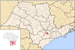
 Location in São Paulo state |
|||
| Location in Brazil | |||
| Coordinates: 23°30′6″S 47°27′29″W / 23.50167°S 47.45806°WCoordinates: 23°30′6″S 47°27′29″W / 23.50167°S 47.45806°W | |||
| Country |
|
||
| Region | Southeast Brazil | ||
| State | São Paulo | ||
| Metropolitan Region | Sorocaba | ||
| Portuguese Empire | 1654 | ||
| Founded by | Baltazar Fernandes | ||
| Named for | Sorocaba River | ||
| Government | |||
| • Type | Sorocaba City Hall | ||
| • Mayor | José Caldini Crespo (Democrats) | ||
| • Speaker of the Council - Municipal Chamber of Sorocaba | João Donizeti Silvestre (PSDB) | ||
| Area | |||
| • Municipality | 450.38 km2 (173.89 sq mi) | ||
| Elevation | 601 m (1,972 ft) | ||
| Population (2015) | |||
| • Municipality | 644,919 | ||
| • Metro | 1,898,000 | ||
| Demonym(s) | Sorocabano (Sorocabanian) | ||
| Time zone | BRT (UTC-3) | ||
| • Summer (DST) | BRST (UTC-2) | ||
| Postal code | 18000 - 18010 - 18020 - 18030 - 18040 - 18050 - 18060 - 18070 - 18080 - 18090 - 18100 | ||
| Phone code | +55 15 | ||
| Municipal Holiday | August 15 | ||
| Website | www.sorocaba.sp.gov.br | ||
Sorocaba (Portuguese pronunciation: [so̞ɾo̞ˈkabɐ]) is a municipality in the state of São Paulo, Brazil. Sorocaba is the eighth-largest city in the state of São Paulo. Outside the Greater São Paulo region, it ranks behind only Campinas, São José dos Campos and Ribeirão Preto. It is part of the Metropolitan Region of Sorocaba. The population is 644,919 (2015 est.) in an area of 450.38 km2.
Over the past twelve years the city has been undergoing extensive urbanization projects, improving streets and avenues, as well as infrastructure for the traffic which the city receives every day.
It is the eighth and fourth municipality in the consumer market in the state outside the Greater São Paulo metropolitan area, with a potential annual per capita consumption estimated at $2,400 for the urban population and $917 for rural areas (7200 people) and twenty-ninth-largest city in Brazil with potential for consumption. Still, it is the fourth-largest city of the state to receive new investments and one of the largest in the country, figuring in the list of 30 cities that create more jobs in Brazil.
Dom Francisco de Sousa, general governor of Brazil (1591 to 1602), believing in the existence of gold in the region, settled the Pelourinho—a Portuguese translation of the English "pillory", symbol of the Royal power, as the village Nova Vila de Nossa Senhora da Ponte de Mont Serrat. When gold wasn't found there, the governor returned to the Royal Court. Twelve years later, Dom Francisco de Sousa changed the name of the village to Itavuvu.
Baltasar Fernandes, a member of an expeditionary group called Bandeirantes, laid the foundation of Sorocaba in the 1654. The chapel of Nossa Senhora da Ponte (which is now the Cathedral located in Fernando Prestes square, downtown) was built by him, along with the São Bento de Parnaíba monastery (now São Bento monastery) years later. It was also Fernandes who brought the first Benedictine monks to teach, assist the poor and the ill, and convert the Native Americans of the region. The monastery was donated to the Benedictines in the year 1660, after which Friar Anselmo da Anunciação and Friar Mauro were chosen to take office. The first streets and houses started to spread around the neighborhood.
...
Wikipedia


