Sonvilier
| Sonvilier | ||
|---|---|---|

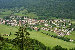
Sonvilier village from the ruins of Erguel Castle
|
||
|
||
| Coordinates: 47°8′N 6°58′E / 47.133°N 6.967°ECoordinates: 47°8′N 6°58′E / 47.133°N 6.967°E | ||
| Country | Switzerland | |
| Canton | Bern | |
| District | Jura bernois | |
| Government | ||
| • Mayor | Maire | |
| Area | ||
| • Total | 23.78 km2 (9.18 sq mi) | |
| Elevation | 802 m (2,631 ft) | |
| Population (Dec 2015) | ||
| • Total | 1,257 | |
| • Density | 53/km2 (140/sq mi) | |
| Postal code | 2615 | |
| SFOS number | 0445 | |
| Surrounded by | Renan, Saint-Imier, Les Bois, Le Pâquier, Dombresson, Chézard-Saint-Martin | |
| Website |
www SFSO statistics |
|
Sonvilier is a municipality in the Jura bernois administrative district in the canton of Bern in Switzerland. It is located in the French-speaking Bernese Jura (Jura Bernois).
Sonvilier is first mentioned in 1298 as Sunuilier. In 1307 it was mentioned as Sonvelier.
Erguel Castle, now in ruins, was built south-east of the village in the 11th century. The castle was the center of government for the lands that the Lords of Arguel (or Erguel) ruled. In 1264 Otto von Erguel, who at the time lived in Basel, ceded the lands to the Prince-Bishop of Basel. In return the bishop granted him lands in Alsace. Under the Prince-Bishop the Erguel lands, including Sonvilier, became part of the seigniory of Erguel. During the 13th and 14th century a local noble family was mentioned in Sonvilier. During the 16th century the municipality was the largest in the Erguel and was home to a half dozen mills that were held in fief to the Prince-Bishop of Basel.
After the 1797 French victory and the Treaty of Campo Formio, Sonvilier became part of the French Département of Mont-Terrible. Three years later, in 1800 it became part of the Département of Haut-Rhin. After Napoleon's defeat and the Congress of Vienna, Sonvilier was assigned to the Canton of Bern in 1815.
...
Wikipedia


