Somogy County (former)
| Somogy County Comitatus Simigiensis (Latin) Somogy vármegye (Hungarian) Komitat Schomodei (German) |
|||||
| County of the Kingdom of Hungary | |||||
|
|||||
|
Coat of arms |
|||||
| Capital |
Kaposvár 46°21′N 17°47′E / 46.350°N 17.783°ECoordinates: 46°21′N 17°47′E / 46.350°N 17.783°E |
||||
| History | |||||
| • | Established | 11th century | |||
| • | Treaty of Trianon | 4 June 1920 | |||
| Area | |||||
| • | 1910 | 6,675 km2(2,577 sq mi) | |||
| Population | |||||
| • | 1910 | 365,961 | |||
| Density | 54.8 /km2 (142 /sq mi) | ||||
| Today part of | Hungary | ||||
Coat of arms
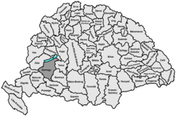
Somogy was an administrative county (comitatus) of the Kingdom of Hungary. Its territory, which was slightly larger than that of present Somogy county, is now in south-western Hungary. The capital of the county was Kaposvár.
Somogy county shared borders with the Hungarian counties Zala, Veszprém, Tolna, Baranya, Verőce and Belovár-Körös (the latter two part of Croatia-Slavonia). It covered the southern shore of Lake Balaton and the region south of the lake. The river Drava (Hungarian: Dráva) formed most of its southern border. Its area was 6530 km² around 1910.
In the 10th century, the Hungarian Nyék tribe occupied the region around Lake Balaton, mainly the areas what are known today Zala and Somogy counties. Somogy county arose as one of the first comitatus of the Kingdom of Hungary, in the 11th century.
...
Wikipedia


