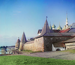
Solovetsky Islands

Solovetsky Islands in 1915 by Prokudin-Gorsky
|
|

Map of the White Sea showing the Solovetsky Islands
|
|
| Geography | |
|---|---|
| Location | Onega Bay, White Sea |
| Coordinates | 65°05′N 35°53′E / 65.083°N 35.883°ECoordinates: 65°05′N 35°53′E / 65.083°N 35.883°E |
| Area | 347 km2 (134 sq mi) |
| Administration | |
|
Russia
|
|
| Oblast | Arkhangelsk Oblast |
| Capital and largest city | Solovetsky |
| Demographics | |
| Population | 861 (2010) |
| Additional information | |
| Official name | Cultural and Historic Ensemble of the Solovetsky Islands |
| Type | Cultural |
| Criteria | iv |
| Designated | 1992 (16th session) |
| Reference no. | 632 |
| Region | Europe and North America |
The Solovetsky Islands (Russian: Солове́цкие острова́), or Solovki (Соловки́), are an archipelago located in the Onega Bay of the White Sea, Russia.
As an administrative division, the islands are incorporated as Solovetsky District of Arkhangelsk Oblast, Russia. Within the framework of municipal divisions, they are incorporated as Solovetskoye Rural Settlement within Primorsky Municipal District. The administrative center of both divisions is the settlement of Solovetsky, located on Bolshoy Solovetsky Island. Almost all of the population of the islands lives in Solovetsky. As of the 2010 Census, the population of the district was 861 inhabitants.
The archipelago has a total area of 347 square kilometers (134 sq mi) and consists of six islands:
The islands separate the Onega Bay from the main volume of the White Sea. The closest mainland is the Onega Peninsula.
The shores of the islands are very indented. They are formed of granites and gneiss. The relief of the islands is hilly (the highest point is 107 m). Most of the Solovetsky Islands are covered with Scots Pine and Norway Spruce forests, which are partially swampy. There are numerous lakes, which were joined by monks so as to form a network of canals.
...
Wikipedia
