Soknedal
| Soknedal herad | |
|---|---|
| Former Municipality | |

View of the church in the distance
|
|
| Municipality ID | NO-1649 |
| Adm. Center | Soknedal |
| Area | |
| • Total | 440 km2 (170 sq mi) |
| Created from | Støren in 1841 |
| Merged into | Midtre Gauldal in 1964 |
| Soknedal | |
|---|---|
| Village | |

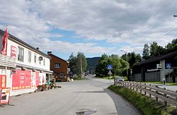
View of the village
|
|
| Location in Sør-Trøndelag | |
| Coordinates: 62°57′04″N 10°11′18″E / 62.95111°N 10.18833°ECoordinates: 62°57′04″N 10°11′18″E / 62.95111°N 10.18833°E | |
| Country | Norway |
| Region | Trøndelag |
| County | Sør-Trøndelag |
| District | Gauldalen |
| Municipality | Midtre Gauldal |
| Area | |
| • Total | 0.32 km2 (0.12 sq mi) |
| Elevation | 243 m (797 ft) |
| Population (2017) | |
| • Total | 2,000-3,000 |
| • Density | 975/km2 (2,530/sq mi) |
| Time zone | CET (UTC+01:00) |
| • Summer (DST) | CEST (UTC+02:00) |
| Post Code | 7288 Soknedal |
Soknedal is a village and former municipality in Sør-Trøndelag county, Norway. It is located in the western part of the present-day municipality of Midtre Gauldal. The administrative center of the municipality was the village of Soknedal, where the Soknedal Church is located. The village and municipality were named after the Soknedal valley, which is named after the Sokna river which runs through the valley.
The 0.32-square-kilometre (79-acre) village of Soknedal has a population (2013) of 312. The population density is 975 inhabitants per square kilometre (2,530/sq mi). It is located along the European route E6 highway about 12 kilometres (7.5 mi) south of Støren and about 20 kilometres (12 mi) north of Berkåk (in Rennebu). The Dovre Line line goes through Soknedal.
The municipality of Soknedal was established in 1841 when the old (large) municipality of Støren was split into three: Horg, Soknedal, and a much smaller Støren. Initially, Soknedal had a population of 1,966. On 1 January 1964, Soknedal was merged with the municipalities of Budal, Singsås, and Støren to form the new municipality of Midtre Gauldal. Before the merger Soknedal had a population of 1,916.
...
Wikipedia


