Sodepur
|
Sodepur/ Sodpur সোদপুর |
|
|---|---|
| Neighbourhood in Kolkata (Calcutta) | |

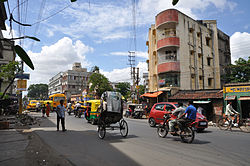
Amarabati More is a busy crossing on 6 no. Barasat road at Sodepur.
|
|
| Location in Kolkata | |
| Coordinates: 22°41′54″N 88°23′22″E / 22.698214°N 88.38947689999998°ECoordinates: 22°41′54″N 88°23′22″E / 22.698214°N 88.38947689999998°E | |
| Country |
|
| State | West Bengal |
| City | Kolkata |
| Railway station | Sodepur |
| Elevation | 15 m (49 ft) |
| Languages | |
| • Official | Bengali, English, Hindi |
| Time zone | IST (UTC+5:30) |
| PIN | 700110 |
| Lok Sabha constituency | Dum Dum |
| Vidhan Sabha constituency | Panihati |
Sodepur (Bengali: সোদপুর) is a place in north Kolkata (formerly Calcutta). It is a part of Panihati municipality under Barrackpur sub-division of the state of West Bengal. It is a part of the area covered by Kolkata Metropolitan Development Authority.
There once was a community named Sayyid in this area from which the place was known as Sayyidpur or Sodepur. Sodepur in the Barrackpore subdivision, is historically famous for the Khadi Prathistan where historic decisions with regard to freedom struggle were taken by Gandhiji and other great leaders like Subhas Chandra Bose. In 1921, Satish Chandra Dasgupta, eminent chemist, resigned from Bengal Chemicals influenced by the Gandhian thought of Swadeshi and set up the Ashram. This ashram near the Sodepur Railway Station has a special place in the history of the Indian independence movement. Mahatma Gandhi called this ashram his second home and stayed there at various times (1939, 1945, 1946, 1947).
Sodepur has a police outpost of its own and it falls under the jurisdiction of Khardaha and Ghola Police station.
Sodepur is located at 22°41′54″N 88°23′22″E / 22.698214°N 88.38947689999998°E. It has an average elevation of 15 m (49 ft).
Sodepur is well connected by the Eastern Railway suburban network. The B.T. road which passes through the heart of the city also provides ample scopes for road transport.
...
Wikipedia

