Snowy Mountains Highway
|
Snowy Mountains Highway New South Wales |
|||
|---|---|---|---|
 |
|||
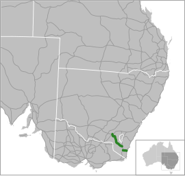
| Snowy Mountains Highway highlighted in green | |||
| Type | Highway | ||
| Length | 287 km (178 mi) 333 km (207 mi) including intervening roadway. |
||
| Route number(s) |
|
||
|
|||
| East end | |||
|
|||
| West end |
|
||
|
|||
| East end |
|
||
|
|||
| West end |
|
||
|
|
|||
| Major settlements | Adelong, Tumut, Adaminaby, Cooma | ||
| General | Within Kosciuszko National Park, it is recommended that two-wheel drive vehicles carry snow chains during winter. | ||
|
Highways in Australia National Highway • Freeways in Australia Highways in New South Wales |
|||
| Eastern section |
|---|
| Western section |
|---|
The Snowy Mountains Highway is a 333-kilometre-long (207 mi)state highway located in New South Wales, Australia. Its two sections connect the New South Wales South Coast to the Monaro region, and the Monaro to the South West Slopes via the Snowy Mountains. The higher altitude regions of this road are subject to snow over the winter months, and the road also provides access to many parts of the Snowy Mountains Scheme. The highway bears the B72 shield along its entire length.
The highway originally bore then name Monaro Highway until 1958, when it received its current name. It originally ran from Tathra to Wagga Wagga but has been shortened to run from the Princes Highway to the Hume Highway instead. Part of the roadway was reallocated to what is now known as the Monaro Highway in 1955. Reservoirs created as a result of dams built in the 1950s and 1960s as part of the Snowy Mountains Scheme required the creation of major realignments to avoid submerged areas. Previous to New South Wales' conversion to alphanumeric route markers, it was signed as National Route 18.
The Snowy Mountains Highway begins at a T-intersection with the Princes Highway at Stony Creek, north of Bega. It heads roughly west through hilly terrain, the terrain smooths eventually and the road crosses the Bemboka River at Morans Crossing. A short distance further, the road passes through Bemboka; taking on the name Loftus Street within the urban area. West of Bemboka, the road follows the southern bank of the Bemboka River, before crossing the Nunnock River near its confluence with the Bemboka River at the base of the Great Dividing Range escarpment. Up until this point the immediate landscape surrounding the road has so far consisted of farmland. From the base of the range the road enters South East Forest National Park and follows a steep and winding alignment up the range from about 250 m (820 ft) above sea level, to over 1,100 m (3,600 ft). At the top of the range the road then enters Glenbog State Forest before once again traversing farmland for a short distance until it meets the Monaro Highway at Steeple Flat, south of Nimmitabel. This intersection is a T-intersection, through traffic continues north on the Monaro Highway, while traffic heading to the south from either direction must turn. To reach the western section of the Snowy Mountains Highway the Monaro Highway must be taken north towards Cooma at this point.
...
Wikipedia
