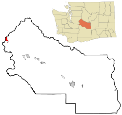
Snoqualmie Pass, Washington
| Snoqualmie Pass, Washington | |
|---|---|
| CDP | |
 Location of Snoqualmie Pass, Washington |
|
| Coordinates: 47°23′32″N 121°24′0″W / 47.39222°N 121.40000°W | |
| Country | United States |
| State | Washington |
| County | Kittitas |
| Area | |
| • Total | 2.9 sq mi (7.4 km2) |
| • Land | 2.9 sq mi (7.4 km2) |
| • Water | 0.0 sq mi (0.0 km2) |
| Elevation | 2,726 ft (831 m) |
| Population (2010) | |
| • Total | 311 |
| • Density | 70.1/sq mi (27.1/km2) |
| Time zone | Pacific (PST) (UTC-8) |
| • Summer (DST) | PDT (UTC-7) |
| ZIP code | 98068 |
| Area code(s) | 425 |
| FIPS code | 53-65275 |
| GNIS feature ID | 1852958 |
Snoqualmie Pass is a census-designated place (CDP) in King and Kittitas County, Washington, United States. The population was 311 at the 2010 census.
The CDP is named for the mountain pass that carries Interstate 90 across the Cascade Range, which itself is named for the Snoqualmie tribe, a Native American tribe indigenous to the Snoqualmie Valley located west of the pass.
Based on per capita income, Snoqualmie Pass ranks 8th of 522 areas in the state of Washington to be ranked. It is also the highest rank achieved in Kittitas County.
With Interstate 90 and the King County/Kittitas County lines splitting Snoqualmie Pass at roughly perpendicular directions, the community lies in two counties, two different zip codes from two different main post offices, two different congressional districts and two different legislative districts. None of these districts have the same border in the community.
The area consists of mountain chalets that are mainly seasonally occupied by residents of the Seattle metropolitan area, with approximately 150 year-round residents. Winter sports are the main draw, but outdoor recreation is available year-round.
The Pacific Crest Trail crosses through Snoqualmie Pass and a variety of other trails are also available for hiking and climbing[1] in the summer, cross-country skiing and snowshoeing during the winter months.
...
Wikipedia
