Snodland
| Snodland | |
|---|---|
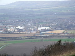
 View over the Medway Gap from Blue Bell Hill with Snodland and the Horseshoe Reach meander of the River Medway with the paper mills in front, and the North Downs behind |
|
| Snodland shown within Kent | |
| Population | 10,211 (2011 Census) |
| OS grid reference | TQ699514 |
| District | |
| Shire county | |
| Region | |
| Country | England |
| Sovereign state | United Kingdom |
| Post town | SNODLAND |
| Postcode district | ME6 |
| Dialling code | 01634 |
| Police | Kent |
| Fire | Kent |
| Ambulance | South East Coast |
| EU Parliament | South East England |
| UK Parliament | |
Snodland is a small town on the River Medway, located between Rochester and Maidstone in the English county of Kent. It is about 27 miles from central London and at the 2011 census had a population of 10,211 people.
"Snoddingland" is first mentioned in a charter of 838 in which King Egbert of Wessex gave "four ploughlands in the place called Snoddingland and Holanbeorge" (Holborough) to Beornmod, the Bishop of Rochester. Since -ingland names are mostly derived from personal names, the name appears to refer to ‘cultivated land connected with Snodd’ or Snodda. The Domesday Book refers to it as "Esnoiland".
The first Roman advance in the conquest of Britain may have crossed the River Medway near Snodland, although there are contending locations. The supposed crossing place is marked by a memorial on the opposite side of the river from Snodland, close to Burham. Near this spot, a ferry later carried pilgrims bound for Canterbury along the Pilgrims' Way.
Bishop Gundulph, at the end of the 11th Century, built a palace at Halling that was used by his successors until the 16th century.
Lime working had been carried out at Snodland for centuries, but expanded dramatically in the 19th Century, as building boomed. The firm of Poynder and Medlicott began quarrying on the Snodland-Halling border in the early 19th century and the company was taken over by William Lee in 1846. Others followed and the last one was built in 1923 by W L H Roberts at Holborough. Lime for building Waterloo and other London bridges came from the area.
The paper-making industry came to Snodland around 1740, when the May family built a mill which the Hook family took over in 1854. New manufacturing techniques and the coming of the railway in the 1850s improved paper production from five to 70 tons a week. Snodland's population doubled between 1840 and 1857. After the Medway Valley railway was opened on 18 June 1856, the village trebled in size between 1861 and 1881. The parish boundary was re-aligned in 1898 and again in 1988 to reflect the growth of Snodland, both changes absorbed areas of Birling Parish, known locally as "Lower Birling".
...
Wikipedia

