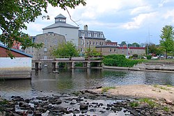
Smiths Falls, Ontario
| Smiths Falls | |
|---|---|
| Town (single-tier) | |
| Town of Smiths Falls | |
 |
|
| Motto: Sensational Smiths Falls | |
| Coordinates: 44°54′N 76°01′W / 44.900°N 76.017°WCoordinates: 44°54′N 76°01′W / 44.900°N 76.017°W | |
| Country |
|
| Province |
|
| County | Lanark |
| Incorporated | 1854 (as village) |
| Government | |
| • Mayor | Shawn James Pankow |
| • Federal riding | Lanark—Frontenac—Lennox and Addington |
| • Prov. riding | Lanark—Frontenac—Lennox and Addington |
| Area | |
| • Land | 9.61 km2 (3.71 sq mi) |
| Population (2011) | |
| • Total | 8,978 |
| • Density | 934.6/km2 (2,421/sq mi) |
| Time zone | Eastern (EST) (UTC−5) |
| • Summer (DST) | Eastern Daylight (EDT) (UTC−4) |
| Postal code FSA | K7A |
| Area code | 613 |
| Website | www.smithsfalls.ca |
Smiths Falls is a town in Eastern Ontario, Canada, with a population of 8,978 according to the 2011 census. It is in the Census Division for Lanark County, but is separated from the county. The Rideau Canal waterway passes through the town, with four separate locks in three locations and a combined lift of over 15 metres (50 ft).
The town's name was sometimes alternatively spelled "Smith's Falls" or "Smith Falls", but "Smiths Falls" is now considered correct.
The city is named after Thomas Smyth, a United Empire Loyalist who in 1786 was granted 400 acres (1.6 km2) in what is present-day Smiths Falls. The Heritage House Museum (c. 1862), also known as the Ward House, was designated under the Ontario Heritage Act in 1977.
At the time of construction of the Rideau Canal a small settlement had been established around a mill operated by Abel Russell Ward, who had bought Smyth's land. Colonel By ordered the removal of Ward's mill to make way for the canal. He settled with Ward for £1,500, one of the largest claims made by mill owners on the canal.
The disruption of industry caused by the building of the canal was only temporary, and Smiths Falls grew rapidly following construction. An article in Smith's Gazetteer in 1846 described the town as a "flourishing little village pleasantly situated on the Rideau River and on the Canal, fourteen miles (21 km) from Perth. It contains about 700 inhabitants. There are fifty dwellings, two grist mills (one with four run of stones), two sawmills, one carding and fulling mill, seven stores, six groceries, one axe factory, six blacksmiths, two wheelwrights, one cabinet maker, one chair-maker, three carpenters, one gunsmith, eleven shoemakers, seven tailors, one tinsmith and two taverns."
A 36-foot (11 m) drop in less than a quarter of a mile posed an obstacle to navigation at Smiths Falls. A natural depression to the south of the river was used to create a flight of three locks, known as Combined Lockstation today. The natural course of the river was dammed to create a basin upstream of the locks. At the upper end of the basin a fourth (detached) lock was constructed.
...
Wikipedia

